Less favourable outlook ahead

Western Australian forecast by Craig Brokensha (issued Friday January 24th)
Best Days: Tomorrow morning, Tuesday morning in the South West, Friday morning next week
Features of the Forecast (tl;dr)
- Mix of easing mid-period NW swell tomorrow and new mix of SW swells, easing Sun
- Variable tending strong S/SW winds to the south tomorrow, variable NW tending W/SW to the north
- Easing surf Sun with strong S/SE-S winds
- Smaller Mon with fres S/SE tending strong S/SW winds
- Small-mod sized mid-period SW swell for Tue with strong E/SE tending S/SW winds
- Easing swell Wed with fresh S/SE-SE AM winds
- Moderate + sized SW groundswell building later Thu, peaking Fri with S/SE tending S/SW winds
Recap
Our tricky N/NW groundswell showed into Wednesday afternoon/evening with an initial pulse of groundswell pushing into metro locations to 2ft, bigger and more 4ft across the South West.
Yesterday was a similar size but cleaner under morning offshores ahead of workable sea breezes, while today our secondary pulse of mid-period NW swell is filling in across all locations.
Margs was 4-5ft this morning with 2ft sets across Mandurah and Perth, increasing a little more this morning but with deteriorating conditions thanks to strengthening N’ly winds. There’s also some new SW groundswell due to be in the mix for this afternoon but with strengthening N/NW winds.

NW swell yesterday morning

W/NW swell this morning
This weekend and next week (Jan 25 - 31)
Today’s strengthening winds are thanks to the remnants of Severe Tropical Cyclone Sean moving down and across us with a shift in winds due tomorrow across the state.
Most locations should see variable winds tomorrow morning, likely lingering from the NW across Perth but easing through the morning ahead of strengthening S/SW breeze in the South West, more W/SW to the north and weaker.
Swell wise we should see the NW energy easing back tomorrow from 3-5ft in the South West and 2ft max to the north, while our mix of SW groundswell and mid-period energy from a strong low that formed west of the Heard Island region earlier week should come in at 5-6ft across the South West, though small to tiny to the north.
With the variable morning winds and mix of swells it’s worth a paddle tomorrow.
Sunday looks average with strong S/SE-S winds due along with easing levels of groundswell only from 4ft max in the South West, tiny to the north.
Next week will start small and winds look to persist out of the S/SE through the morning, though with less strength than Sunday, while some new mid-period SW swell due into Tuesday though to no major size.
This will be generated by a weak frontal system moving towards us over the weekend, with fetches of strong W/SW winds due to generate a small kick to 4ft+ in the South West, tiny to the north.
Conditions will be nice and clean but tricky with a strong E/SE offshore on Tuesday, S/SW into the afternoon with easing surf Wednesday under less favourable S/SE-SE winds.
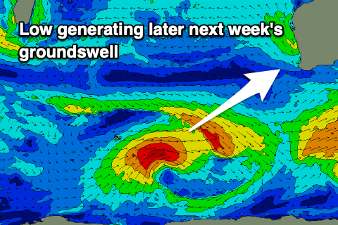
The next notable increase in swell is due later Thursday but more so Friday, generated by a small, tight polar low around the Heard Island region Sunday/Monday.
With core winds reaching gale-force we should see 6ft surf from this system in the South West (1-2ft to the north) but with local S/SE winds. Check back here Monday for confirmation. Have a great weekend!