Large swells inbound but with less than ideal winds

Western Australian Forecast by Craig Brokensha (issued Friday January 10th)
Best Days: Tomorrow morning in the South West, possibly Sunday morning in the South West, Wednesday morning protected spots, Thursday morning in the South West
Features of the Forecast (tl;dr)
- Slowly easing swell all weekend with light E/SE-SE winds ahead of sea breezes tomorrow (S/SE to the north), variable Sun AM before freshening out of the W-SW
- Smaller early Mon ahead of a large mix of building W/SW swells into the PM
- Light S-S/SE winds Mon ahead of sea breezes
- Large peak in W/SW groundswell Tue AM, easing
- Strong SW tending S/SW winds Tue
- S-S/SW winds in the South West Wed, freshening through the day with lighter S/SE-SE winds to the north in the AM
- Smaller Thu with E tending SW winds
Recap
A small lift in swell with light winds was seen across the South West yesterday, a little bigger today but with less favourable winds.
This weekend and next week (Jan 11 - 17)
Today’s building swell is due to peak later today but ease off slowly over the weekend thanks to the slow moving nature of the low linked to it.
The South West should ease back from 4-6ft tomorrow morning with 1-2ft sets in Mandurah, 1-1.5ft across Perth.
Conditions look cleaner with a light E/SE-SE breeze due across the South West, lingering S/SE to the north before sea breezes kick in, with Sunday coming in a touch dicey as a trough starts to edge in from the west.
Most locations are likely to see variable winds before shifting onshore through the morning along with a little less size compared to tomorrow morning.
A temporary low point in swell is expected on Monday, while into the afternoon a mix of large, mid-period and long-period groundswell are due to arrive, peaking through Tuesday morning across the South West.
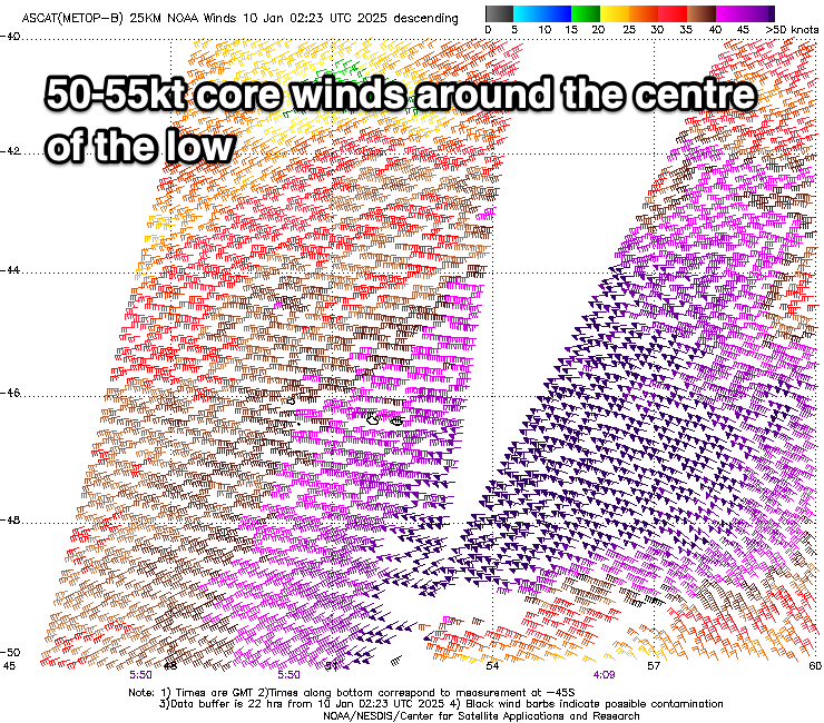
The source of both these swells is a strong low that we’ve been talking about for a few updates. The low formed to the south-east of South Africa and has been generating fetches of storm-force W’ly winds, weakening slowly while tracking east today and then further this evening and tomorrow while projecting a little more towards us.
What will result is a large, long-period W/SW groundswell with the South West due to peak Tuesday morning to 10-12ft across the South West, 3ft+ in Mandurah and 2ft to occasionally 3ft across Perth.
Unfortunately the remnants of the swell producing system will move in Tuesday, bringing strong SW tending S/SW winds that will then ease but likely remain out of the S-S/SW across the South West Wednesday, more offshore to the north.
This will be easing levels of swell (moderate to large in size), cleaner in the South West on Thursday but much smaller.
Into next weekend, another large pulse of W/SW groundswell is due from a weaker but broader and slower moving storm progression through the southern Indian Ocean. More on this Monday. Have a great weekend!