Good surf tomorrow with a quality S/SW groundswell early next week

Western Australian Forecast by Craig Brokensha (issued Wednesday March 6th)
Best Days: Today, tomorrow, metro locations Saturday morning, Monday morning in the South West, Tuesday morning, Wednesday morning in the South West
Features of the Forecast (tl;dr)
- Easing mid-period SW swell tomorrow with mod-fresh E/NE tending NW winds in the South West, SW to the north
- Smaller Fri with early N/NE tending strong SW winds
- Weak, moderate + sized S/SW swell Sat with mod-fresh S/SE winds
- Easing swell Sun with gusty SE tending S/SW winds
- Smallish Mon AM with E/SE tending S/SW winds.
- Late increase in S/SW groundswell Mon, peaking Tue AM with gusty SE tending S/SW winds
- Easing surf Wed with strong SE tending S/SE winds
Recap
Nothing of note yesterday, but into today, our good pulse of SW swell energy has filled in with building surf that’s now 6ft+ across the South West, 2ft in Mandurah and 1-2ft across the Perth magnets. Conditions are still clean and should remain so to the north with weak sea breezes to the south.

Midday cleanups today
This week and weekend (Mar 7 - 10)
Today’s swell is now peaking and we’ll see it backing off slowly into tomorrow though still coming in at a good 4-6ft across the South West magnets in the morning and 1-2ft to the north.
Conditions will be great with a moderate to fresh E/NE offshore ahead of SW sea breezes to the north and NW sea breezes to the south.
Friday looks smaller and winds look dicey as an early N/NE breeze shifts W/SW and then stronger SW into the afternoon as an approaching trough clips the region.
As touched on in Monday’s update, the trough will bring a weak increase in sizey swell for Saturday, with a fetch of strong to near gale-force SW winds due to generate a spike to 5-6ft across the South West, with 2ft peaks to the north.
Winds will still be an issue Saturday and moderate to fresh from the S/SE, with Sunday seeing slightly more favourable SE breezes but with easing 4ft sets in the South West, tiny to the north.
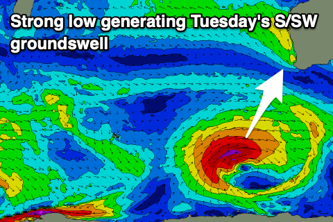
Of greater importance is the follow up polar low forming east of the Heard Island region on Friday. This low will be slow moving, generating a great fetch of severe-gale W/SW winds through our southern swell window right through until Sunday morning. After this it will push off east under the country.
A large S/SW groundswell is expected from this source, with forerunners due to arrive later Monday ahead of a peak Tuesday morning to 8ft on the sets in the South West, 2ft across Mandurah and 1-2ft in Perth.
Winds look generally fresh from the SE, possibly tending E/SE at times through the morning ahead of sea breezes, with strong SE winds persisting Wednesday as the swell fades.
Beyond this there’s nothing major due until late next weekend/early the following week, but more on this Friday.