Fading surf with strong morning offshores

Western Australian Surf Forecast by Craig Brokensha (issued Friday November 24th)
Best Days: No good days
Features of the Forecast (tl;dr)
- Fading surf on the weekend with strong E/SE winds tomorrow, easing ahead of strong S/SE sea breezes
- Tiny Sun with strong E/NE winds, easing for a period during the day
- Tiny Mon with strong E/NE winds, easing and tending N/NW-NW
- Moderate W/NW-NW winds Tue with a small, building mid-period SW swell for the PM, easing Wed with strong SW winds
- Small inconistent SW groundswell Thu/Fri with S-S/SE tending S/SW winds Thu, S/SE-SE tending S/SW Fri
- Easing surf Sat with E/NE-E tending SW winds
Recap
Clean though windy conditions across the South West with a slight drop in swell back to the 3ft range yesterday, smaller and less consistent and to 2-3ft today. Perth and Mandurah have been hot but tiny, milder today.
This weekend and next week (Nov 25 – Dec 1)
There's nothing to surf over the weekend with the current swell due to fade into tomorrow, becoming even smaller Sunday leaving nothing to surf.
The wind will do its best to knock the top off any remaining background energy, with strong offshore winds linked to a stalling heat trough/low sitting west of the state.
Strong, morning E/SE winds are due tomorrow, easing and then tending strong S/SE into the afternoon. Sunday will then see strong E-E/NE winds, easing temporarily during the day and then picking up again into the afternoon/evening.
Winds will start to shift E/NE on Monday and then N/NW-NW while easing as the low/trough starts to shift south-east across us.
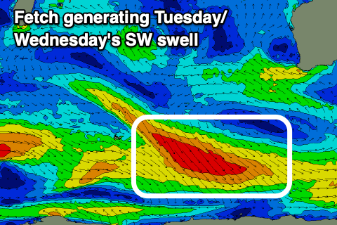
This will leave NW winds across the South West on Tuesday, W/NW across Perth and Mandurah along with a small, pulse of mid-period SW swell building through the afternoon, peaking Wednesday morning.
The source of this swell is a strong but poorly aligned fetch of strong to gale-force W/NW-NW winds east of the Heard Island region, with side-band energy due to peak later Tuesday and early Wednesday morning to 4ft across the South West, tiny in Perth and Mandurah.
Winds will unfortunately spoil this small swell, switching strong SW after Tuesday's W/NW-NW breezes, with slightly better S-S/SE winds on Thursday morning though with a small, inconsistent background SW swell due to build through the afternoon, followed by a secondary pulse Friday.
The source of these swells is weak, generally indiscernible storms, with the size not expected to budge above 4ft across the South West and 1ft to the north. Winds look to remain S/SE-SE on Friday morning, better and E/NE-E on Saturday morning but with easing surf.
Longer term we may see a slight improvement regarding swell generating systems but with associated onshore winds. A no win situation. More on this Monday. Have a great weekend!