Easing surf with deteriorating winds, dicey next week

Western Australian Surf Forecast by Craig Brokensha (issued Friday October 6th)
Best Days: Today, tomorrow morning Mandurah for a small wave, Sunday morning, later next week and weekend
Features of the Forecast (tl;dr)
- Easing S/SW groundswell into tomorrow with gusty S/SE tending S/SW winds in the South West, lighter E/SE to the north in the AM
- Moderate sized SW groundswell for Sun with NE-N/NE tending N/NW then W winds
- Easing swell Mon with W/SW winds in the South West, SE to the north
- Moderate sized, mid-period W/SW swell building Tue, peaking Wed AM
- SW winds Tue (S/SE to the north in the AM)
- Strong SW winds Wed
- Improving winds later next week with inconsistent pulses of W/SW groundswell, peaking next weekend
Recap
Small surf yesterday morning with clean conditions and fun waves on the small wave breaks. A large, new long-period S/SW groundswell due into the afternoon started to build through the day as sea breezes kicked in but it looks like the peak was seen this morning with great, strong 8-10ft sets across the South West, 3ft Mandurah and 2ft Perth. Conditions are great and will remain so ahead of sea breezes.


Sharing is caring when it's 10ft (this morning)
This weekend and next week (Oct 7 - 13)
Our current large S/SW groundswell is due to ease into tomorrow and winds are now looking dicey as a trough strengthens to our north, bringing strong S/SE winds to the South West, lighter E/SE to the north ahead of sea breezes. These dicey winds are only being picked up by the high resolution wind models.
The swell looks to ease back from the 5-6ft range across the magnets in the South West, 2ft Mandurah and 1-1.5ft across Perth.
A fun pulse of reinforcing SW groundswell for Sunday is on track, generated by a great fetch of gale to severe-gale W/NW winds pushing in across the Heard Island region.
A kick back to 6ft is due on the South West magnets, 2ft Mandurah and 1-1.5ft across Perth with NE-N/NE winds, favouring south swell magnets. Winds will shift N/NW late morning and then W-W/SW into the afternoon/evenin as a trough clips us, bringing the change.
The source of this groundswell will be a fetch of gale to severe-gale W/NW winds trailing the low linked to tomorrow's swell. The South West should kick back to 5-6ft with smaller waves to the north coming in at 1-2ft across Mandurah and 1-1.5ft in Perth.
Moving into next week, onshore winds look to linger across the South West Monday, cleaner to the north but small to tiny.
A small spike of mid-period W/SW swell is due to build Tuesday, peaking Wednesday morning, generated by the remnants of a weak front moving in through the Indian Ocean forming into a low west-southwest of us on Sunday. A short-lived fetch of W/SW gales should produce a spike in swell to 4-5ft+ across the South West magnets at its peak, 2ft Mandurah and 1-2ft Perth.
Winds look to remain onshore Tuesday from the SW across the South West, S/SE to the north with Wednesday at the peak of the swell looking poor across all locations as the swell generating low brings strong SW winds.
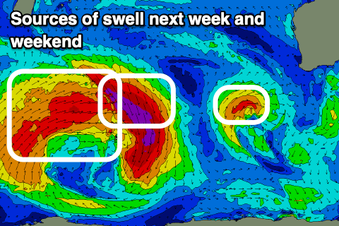
The next swell generating system will be a broad broad, low firing up to the south-east of South Africa on Sunday.
Unfortunately the peak wind strength will be on the north-eastern flank, aimed towards the polar shelf, with weaker W/SW winds pushing up in our south-western swell window.
We should see mutiple pulses of W/SW groundswell generated from this low, smaller first from the NW fetch Friday and then larger from the W/SW fetch Saturday/Sunday.
We'll have a closer look at the sizes on Monday along with the winds but they look favourable at this early stage. Have a great weekend!