Easing surf as winds deteriorate, stormy early next week

Western Australian Surf Forecast by Craig Brokensha (issued Wednesday September 27th)
Best Days: Today, protected spots tomorrow morning, Wednesday morning, Thursday and Friday next week
Features of the Forecast (tl;dr)
- Easing W/SW groundswell tomorrow with mod-fresh S/SE tending stronger S/SW-SW winds
- Smaller surf Fri with moderate S/SE tending freshening W/SW winds
- Moderate sized + mid-period W/SW swell building Sat with fresh W/SW winds
- Strengthening W/NW-NW winds Sun with building windswell
- Oversized, stormy swell building Mon with strong W/SW winds
- Peak in oversized W/SW groundswell Tue AM, easing through the day
- Fresh S/SW winds Tue
- Smaller Wed with variable tending NW winds
- Cleaner Thu with smaller surf
- Possible good S/SW groundswell late week
Recap
Light winds and smaller surf yesterday with OK waves for the keen in the South West, better to the north in Perth and Mandurah.
Today our large W/SW groundswell has filled in and not seeing the source winds before Monday it looks to have been generated by a longer lived frontal system than first thought. The South West is pumping and to 8ft+ with 2-3ft waves in Mandurah and 2ft sets across Perth. Mandurah should reach a more consistent 3ft through the day with 2ft+ waves across Perth as winds go N'ly and ease.

Pumping surf this morning
This week and weekend (Sep 28 – Oct 6)
The current strong W/SW groundswell will ease through tomorrow and a trough will bring a S'ly change, though there should be pockets of S/SE breezes through the morning before strengthening and shifting S/SW-SW into the afternoon.
The South West looks to ease back from 6ft+ across exposed breaks, 2-3ft in Mandurah and 2ft across Perth.
Slight better, weaker S/SE winds are due early Friday morning but with smaller surf, and an approaching mid-latitude front will see winds shift W/SW and strengthen through the day.
The front will also bring an increase in moderate sized mid-period W/SW swell through Saturday afternoon, holding Sunday but the next approaching frontal progression will bring poor, W/SW winds on the former, strengthening from the W/NW-NW on Sunday as the progression proper moves in.
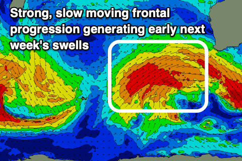
Now, as touched on in Monday's outlook this slow moving frontal progression will generate oversized, stormy swell into early next week as it projects a fetch of strong to gale-force W/SW winds up, into the state from Saturday through Monday.
The progression will move across us Monday, bringing strong W/SW winds and a building localised swell that will then be followed by the groundswell Tuesday.
The South West looks to peak Tuesday morning to 12ft+, 3-5ft across Mandurah and 3-4ft in Perth. Later Monday stormy waves to a similar size are due across all locations.
The progression should start to clear Tuesday resulting in weakening but lingering S/SW winds, better and variable Wednesday morning across the South West, E/NE to the north.
The swell looks to ease back from 6ft to occasionally 8ft Wednesday morning in the South West, 2-3ft to the north, smaller Thursday with more reliable offshore winds.
Some good, moderate-large reinforcing S/SW groundswell is on the cards for later in the week but we'll have a closer look and confirm this Friday.