Slow period ahead

Western Australian Surf Forecast by Craig Brokensha (issued Friday August 25th)
Best Days: Today in the South West, desperate surfers in the South West tomorrow morning, Monday morning in the South West, Tuesday morning Margs and Mandurah, Thursday Margs and Mandurah, Friday morning Mandurah and Perth
Features of the Forecast (tl;dr)
- Small surf Sat (reinforcing S/SW swell for the late PM, easing Sun) with moderate NE tending N winds
- Smaller Sun with N/NE-NE tending strong N/NW winds
- Moderate sized + S/SW groundswell building Mon with SE tending S/SW winds
- Easing surf Tue with gusty E/SE winds, tending S/SW
- Smaller Wed with E/SE tending S/SW winds
- Moderate + sized mid-period SW swell building Thu with E/SE tending SW winds, holding Fri with S/SW winds (SE to the north)
Recap
Mandurah and Perth continued to offer great surf through yesterday with excellent conditions and a slow drop in size, easing from 2ft+ across the former and 2ft across the latter. Margs was onshore and bumpy through the morning with sets to 5-6ft, but with easing winds through the day, conditions slowly improved for the keen.
This morning winds were finally offshore across the Margaret River region but with a smaller easing swell from the 4-5ft range on the sets. Perth and Mandurah were small but nice and clean. Make the most of today's conditions as the weekend looks smaller.

Clean fun sized surf this AM
This weekend and next week (Aug 26 – Sep 1)
The surf will drop further in size tomorrow and winds won't be as favourable with a moderate NE'ly due to shift more N'ly through the day.
Smaller 3ft waves are due in the South West, tiny across Perth and Mandurah, while a small, reinforcing pulse of mid-period S/SW swell due late in the day is expected to maintain similar sized sets early Sunday (2-3ft), fading through the day.
NE-N/NE winds are again due at dawn on Sunday, shifting quickly to the N/NW and strengthening.
This will be ahead of a trough, with it bringing an overnight change with winds expected to shift back to the SE for Monday morning.
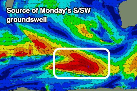
Our new pulse of S/SW groundswell for Monday is on track, generated by a burst of W/NW gales along the polar shelf, east of the Heard Island region last night and into today.
We should see the South West build to 4-5ft+ (possibly a touch undersized early) building to 1-2ft in Mandurah and 1-1.5ft across Perth, easing from a similar if not slightly smaller size Tuesday.
Sea breezes are due into Monday afternoon with Tuesday offering E/SE tending S/SE winds.
Wednesday looks smaller again with morning offshore winds, while a new moderate sized mid-period SW swell is due to build Thursday with offshore winds persisting through the morning.

The source of this swell and a reinforcing pulse for Friday is broad but not overly strong frontal activity swinging in from the south-east of South Africa. Fetches of strong to near gale-force W/NW-W winds, generating a moderate+ sized SW swell.
Building surf to 6ft is due Thursday afternoon, 2ft+ in Mandurah and 1-2ft across Perth, holding Friday but with what looks to be S/SW winds as a trough moves through.
We're looking at stronger, closer-range frontal activity into late next week/weekend, generating larger surf next weekend more to the 8ft range. Winds look dicey and possibly lingering onshore but we'll review this on Monday. Have a great weekend!