Large, onshore surf to come

Western Australia Surf Forecast by Craig Brokensha (issued Friday July 7th)
Best Days: Perth and Mandurah tomorrow, early Sunday and Monday mornings, Friday morning next week
Features of the Forecast (tl;dr)
- Mod-large mid-period SW swell tomorrow, easing Sun
- Mod-fresh W-W/NW winds in the South West, lighter E/NE-NE tending N/NE and then NW in the north
- Strengthening NW winds Sun, mod-fresh N/NE early Perth and Mandurah
- Large mid-period SW swell building Mon with strong NW winds in the South West, mod-fresh N/NE early Perth and Mandurah
- XL, long-period W/SW groundswell building Tue PM, easing slowly Wed
- Strengthening W/NW-NW winds Tue, strong NW Wed
- Oversized reinforcing SW swell Thu with strong SW winds
- Easing surf Fri with possible light winds in the AM
Recap
Lumpy though cleaner conditions across Mandurah yesterday morning with a variable wind, while in Perth winds were light before dawn but then came onshore for day break, creating bumpy 2-3ft surf. Margs was poor and onshore.
Today conditions are again poor across all locations as a strong frontal system clips the state.
This weekend and next week (Jul 8 - 14)
Today's front will bring with it some decent mid-period SW energy tomorrow that should keep Mandurah up around 3ft tomorrow with 2-3ft sets across Perth with large, unruly options in the South West.
As the front quickly clears to the east, will we get a window of favourable winds for Perth and Mandurah?
It looks so with winds due to abate quite rapidly overnight, leaving E/NE-NE winds to the north along with lumpy conditions, moderate to fresh W tending W/NW in the South West. Weak NW breezes are due into the afternoon across Perth and Mandurah offering a full day of workable conditions.
Sunday will be less favourable but still surfable with a moderate to fresh N/NE breeze in Perth and Mandurah shifting NW and strengthening into the afternoon so surf early. The South West will be poor and onshore all day. The swell is due to be a touch down on Saturday but still fun in the metro locations.
A large, reinforcing mid-period SW swell from a great fetch of strong to gale-force W/SW winds looks to build to 3ft across Mandurah on Monday afternoon with 2-3ft sets to the north and winds should play out similar to Sunday, with a window of workable conditions to the north.
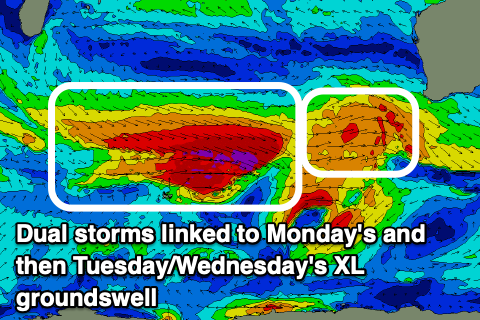
Come Tuesday we're set to see strengthening NW-W/NW winds moving in across all locations thanks to one of the strongest fronts in the progression moving east, clipping us.
This front will generate a fetch of severe-gale W/NW winds on top of an active sea state with a tight fetch of trailing severe-gale to storm-force W/SW winds forecast.
An XL, long-period W/SW tending SW groundswell should be generated by the front, filling in strongly Tuesday afternoon and holding Wednesday morning.
We're expected to see the South West peaking in the 15ft range with 4-5ft sets in Mandurah and 3-4ft waves across Perth.
Unfortunately strong NW winds will persist on Wednesday as the next swell producing system races in from the west, bringing a SW change Thursday and a reinforcing pulse of oversized, mid-period SW swell for the state.
With this trailing front being a little less favourably aimed, generating severe-gale W/NW winds late in our swell window, followed by strong to gale-force SW winds, we can expect a little less size and power compared to Tuesday/Wednesday's swell.
There's a chance for lighter, more variable winds Friday when the swell starts to ease but we'll have to review this Monday.
Longer term the frontal activity looks to move back in through the following week, but we'll look at this closer on Monday. Have a great weekend!
Comments
Thx crg. Are these systems likely to move further south as we move out of a la Nina pattern...?