Fun tomorrow, becoming windy and large into the weekend

Western Australia Surf Forecast by Craig Brokensha (issued Wednesday July 6th)
Best Days: Today, tomorrow, selected spots early Friday, Monday, Tuesday morning
Features of the Forecast (tl;dr)
- Smaller tomorrow AM ahead of a new, mid-period SW swell building into the PM with a secondary pulse Fri PM, easing Sat
- Moderate E/NE tending variable NE winds tomorrow, moderate E/NE-NE tending strong N Fri, N/NW later in Margs
- Strong N tending NW-W/NW winds Sat
- Oversized mix of W'ly swells building Sun with strong W/SW tending SW winds
- Large easing surf Mon with E/NE-NE winds in Perth/Mandurah, variable in the South West
Recap
Poor surf all day across the South West yesterday with the morning onshore winds not abating and easing like was forecast on Monday. They did though play out to forecast in Mandurah and Perth with morning N'ly winds shifting S/SE through the day along with 2ft sets in Perth and 2-3ft waves across Mandurah.
This morning is much cleaner across all locations with offshore winds and surf either side of 5ft in the South West, 2-3ft in Mandurah and 2ft across Perth. The swell has perked up a bit on the Cape Naturaliste buoy but this is just the swell that was expected this morning with more consistent 6ft sets on the magnets.
This week and weekend (Jul 7 - 10)
Tomorrow is the pick of the coming days before we see winds getting into the coming swells.
Today's W/SW and SW energy will ease back into tomorrow morning ahead of an inconsistent pulse of mid-period SW swell into the afternoon. A moderate E/NE tending variable NE breeze is due along with easing sets from 4-5ft in the South West, 1-2ft in Mandurah and Perth.
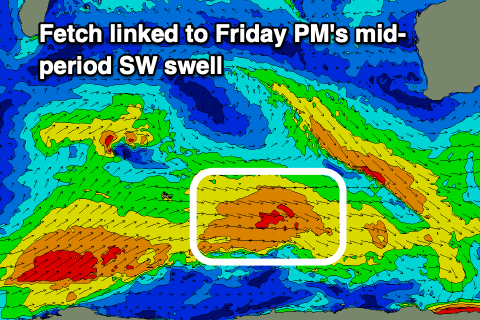 The new mid-period swell and a reinforcing pulse for Friday afternoon have been generated by a broad and healthy but not overly strong polar frontal progression developing south-west of us the last few days.
4-6ft surf is due in the South West tomorrow afternoon, more so 6ft Friday afternoon, then easing Saturday morning. 2ft sets are due in Mandurah and inconsistent 1-2ft waves in Perth.
Winds will deteriorate with an approaching low/cold front on Friday, moderate E/NE-NE at dawn, strengthening quickly and shifting N'ly through the middle of the day and then N/NW later in the South West.
Saturday will be a write-off with strong N tending NW-W/NW winds ahead of a strong W/SW tending SW change on Sunday.
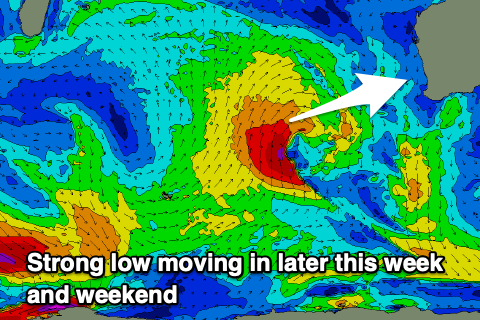 Now, on Monday the low forming west of us wasn't expected to be favourable aimed, generating a swell more for Indonesia than us, but it's now expected to be good for both our regions.
We'll see the mid-latitude low projecting a persistent fetch of S/SW-SW gales at angles to our swell window, weakening on approach but still being strong while pushing into us Sunday.
An oversized W/SW groundswell is expected from this low, mixed in with building local windswell Sunday, peaking later Sunday, then easing Monday.
12ft+ surf is due in the South West, 4-5ft across Mandurah and 3-4ft in Perth, easing Monday from 10-12ft, 3-4ft and 3ft respectively.
Winds are due to ease into Monday as the low clears to the east, with light E/NE-NE breezes across Perth and Mandurah with more variable and possibly lingering W'ly winds in the South West (we'll review this Friday).
The swell will continue to ease into Tuesday and Wednesday but another approaching front from the south-west will quickly tip winds back to the northern quadrant.
Another round of large, stormy onshore surf is on the cards for later next week but we'll have a closer look at this Friday.