Fun weekend with smaller surf

Western Australia Surf Forecast by Craig Brokensha (issued Friday June 24th)
Best Days: Tomorrow all locations, early Sunday all locations, Tuesday and Wednesday all locations, Friday selected spots
Features of the Forecast (tl;dr)
- Easing SW swell tomorrow with a reinforcing mid-period SW swell for the PM, easing Sun
- Variable winds tomorrow (light offshore in the AM) with moderate NE tending stronger N/NW winds Sun (lighter N in the PM Perth and Mandurah)
- Building W/SW swell later Mon with strong W/NW tending S/SW winds (variable early Perth)
- Moderate sized mix of W/SW-SW swell Tue with light E tending variable winds
- Secondary reinforcing pulse of swell Wed with fresher E/NE winds
- Inconsistent W/SW groundswell for Fri with fresh NE tending N/NE winds
- Larger groundswells next weekend
Recap
Large surf with improving conditions across all locations yesterday as a trough brought a north tracking change in the wind and weather. Perth and Mandurah were solid and lumpy early but got better as the day progressed with bumpy surf in the South West, improving into the afternoon as winds eased and tending more S'ly.
Today is the pick though with clean conditions across all locations and plenty of large swell still in the mix. Margs is easing from 10-12ft, 3ft in Mandurah and 2-3ft across Perth.
This weekend and next week (Jun 25 – Jul 1)
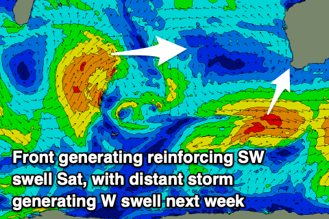
Our current large swell will ease this afternoon and continue to drop in size tomorrow, but the easing trend should be stopped by the arrival of a reinforcing mid-period SW swell.
This has been generated by a cold front on the backside of the strong low moving through our swell window this week and we should see the South West maintaining 6ft surf during tomorrow, 2ft+ in Mandurah and 2ft across Perth on the sets.
 The swell should then ease Sunday from 4-6ft in the South West, 1-2ft across Mandurah and Perth.
Winds are now looking better across the South West tomorrow as a weak front doesn't have enough strength to override morning land breezes. A light, variable E/NE breeze is due in the morning, remaining variable into the afternoon with E/NE-NE tending variable winds to the north.
Sunday looks best early with a moderate NE offshore across all locations, strengthen from the N/NW into the afternoon across the South West, lighter from the N'th to the north.
Monday will most likely be a lay day with strong W/NW winds across the South West ahead of a S/SW change, clean early in Perth but tiny.
Some weak new W/SW swell may be seen into the afternoon but Tuesday is a better chance for this.
The source of the W/SW energy is a low that's formed south-east of Madagascar, generating a fetch of strong to gale-force SW winds in our western swell window before tracking north and away from us this evening and tomorrow. A secondary low firing up more favourably through our swell window today and through the weekend should generate some additional swell to the mix Wednesday afternoon.
Size wise Tuesday's swell looks inconsistent and to 4-6ft in the South West with 2ft sets across Perth and Mandurah. The reinforcing swell for Wednesday looks to be a similar size. Winds will be good and E'ly tending variable on Tuesday, similar Wednesday but more E/NE and fresher.
 Into the end of the week winds will swing more to the north with a drop in size Thursday ahead of a new, inconsistent W/SW groundswell Friday. Compared to what's to come into next weekend and the following week, this swell isn't anything special, generated by a patchy though initially strong polar low firing up south-east of South Africa.
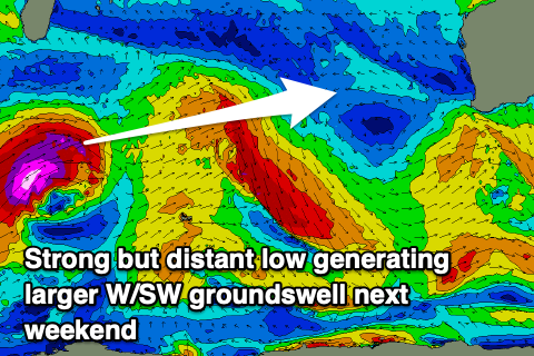
Of greater significance is a very strong mid-latitude low develop south-east of South Africa, followed by a multi-threaded polar frontal progression. This looks to generate larger W/SW groundswell energy from next weekend but winds look dicey. More on this Monday. Have a great weekend and make the most of today.