Large surf inbound as winds improve

Western Australian Surf Forecast by Craig Brokensha (issued Wednesday June 22nd)
Best Days: Tomorrow Perth and Mandurah, protected spots in the South West, Friday all locations, Saturday all locations, early Sunday selected spots
Features of the Forecast (tl;dr)
- Large, strong W/SW groundswell peaking tomorrow morning with S/SE winds across Perth and Mandurah, S/SW Margs (tending S/SE late)
- Easing W/SW and SW swell Fri with E/SE tending variable winds in Perth and Mandurah, light E/NE tending mod W/SW-SW winds in Margs
- Moderate sized, reinforcing mid-period SW swell Sat with E/SE tending NE winds
- Easing surf Sun with fresh NE tending N/NW winds
Recap
Fun surf across Perth yesterday with a drop in swell to 2ft to occasionally 3ft and cleaner conditions. Mandurah was a little raw and wind affected still, with average, onshore surf across the South West.
Today the swell is smaller and best in Perth again, average across Mandurah and onshore in the South West. We should see large levels of W/SW groundswell starting to build this afternoon but with strengthening NW winds.
This week and weekend (Jun 23 - 26)
This afternoon’s initial kick in large W/SW groundswell will be followed by a secondary larger pulse of energy tomorrow, generated by a strong, slow moving low in the southern Indian Ocean since the weekend.
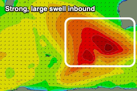 Strong surf either side of 12ft is due across the South West tomorrow morning, 4ft in Mandurah and 3ft+ across Perth.
Winds are now looking more favourable for the northern regions through the morning with a high pressure system due to move in early tomorrow, swinging winds S/SE, likely holding most of the day if not reverting back to the S at times. The South West will be bumpy with S/SW winds, improving later and swinging S/SE.
Friday looks cleaner across a wider variety of locations along with plenty of size. The easing trend will be slowed by trailing fetches of strong to gale-force winds on the backside of the low and we should see light E/SE-E winds across Perth and Mandurah, light E/NE in the South West.
Weak afternoon sea breezes are expected in the metro locations, while a weak front will bring W/SW-SW winds in Margs. Size wise Margs should ease back from the 10ft range on the sets, 3ft in Mandurah and 2-3ft across Perth.
 Saturday looks to become clean again across the South West with a light E/SE offshore, tending NE and remaining light into the afternoon, with freshening NE tending N/NW winds on Sunday ahead of the next approaching front.
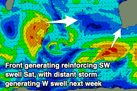
A reinforcing pulse of mid-period SW swell is due Saturday, produced by weak but persistent trailing fetches of strong to gale-force W/SW winds and this should maintain 5-6ft sets in the South West, 2ft across Mandurah and 1-2ft in Perth. The swell will ease Sunday with those deteriorating winds.
Looking longer term and the interaction of a high to our east and a weak surface trough to our west will see persistent NE winds develop, along with moderate pulses of mid-period swell ahead of a stronger W/SW groundswell later week and next weekend. The first pulse of W'ly swell is due Tuesday, but more on this in Friday’s update.