Large, strong W/SW groundswell due this week

Western Australian Surf Forecast by Craig Brokensha (issued Monday June 20th)
Best Days: Protected spots Thursday (best late), Friday, Saturday Perth and Mandurah, Sunday morning Margs and Mandurah
Features of the Forecast (tl;dr)
- Easing surf tomorrow with gusty NW winds in Margs, moderate N/NE in Perth and Mandurah during the AM
- Similar winds Wed with a large, building W/SW groundswell
- Peak in large W/SW groundswell Thu with strong but easing S/SW winds, tending S/SE later
- Easing large SW swell Fri with light E winds in Perth and Mandurah (E/NE Margs), variable into the PM
- Smaller Sat with E/NE tending variable winds Perth and Mandurah, light W Margs (possibly variable)
- Easing surf Sun with NE winds in Margs, E/NE Perth and Mandurah
Recap
Poor conditions across all locations on the weekend with oversized, developing stormy surf and strong onshore winds.
The swell started to ease through yesterday and this morning it’s dropped further but with cleaner conditions across Perth, still lumpy in Mandurah and unfortunately bumpy and onshore across Margs. Perth is the best with 2-3ft peaks, bigger and to 3-4ft in Mandurah with more size again in the South West.
This week and weekend (Jun 21 - 26)
Looking at the week ahead and we’ve got a large W/SW groundswell due and winds look best and most favourable as it eases into the end of the week.
Tomorrow will be smaller across all locations and conditions will remain poor across the South West with a strengthening N/NW breeze, moderate N/NE further north in Perth and Mandurah. Smaller 1-2ft waves are due across Perth, 2ft in Mandurah and 4-5ft+ in Margs.
Similar winds are due into Wednesday and we’ll see an initial pulse of building W/SW groundswell ahead of the largest pulse very late in the day, peaking Thursday morning.
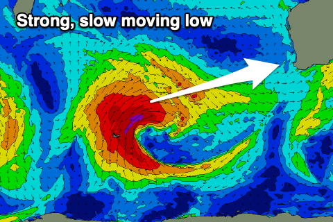 These swells have and are still being generated by strong low that formed south-east of Madagascar, and is now producing a fetch of gale to severe-gale W-W/SW winds north of the Heard Island region.
The low will push slowly east while weakening slightly, bringing onshore winds when the swells kick on Wednesday and Thursday.
Building surf to 8ft+ is expected in the South West Wednesday afternoon, 2-3ft in Mandurah and Perth but with those NW-W/NW winds across all locations, while Thursday should see surf to 12ft across the South West Magnets, 4ft in Mandurah and 3ft+ across Perth.
Winds will start improving on Thursday as the frontal progression clears to the east, allowing winds to swing around to the S/SW (strong in the South West and fresh across Mandurah and Perth), shifting S/SE on dark.
 Friday looks the cleanest and there’ll still be plenty of size in the mix owing to the slow moving nature of the frontal progression and long tail. Light E winds are due across Perth and Mandurah with E/NE winds in Margs along with easing sets from 10ft. Mandurah should ease back from 3ft with 2-3ft sets in Perth.
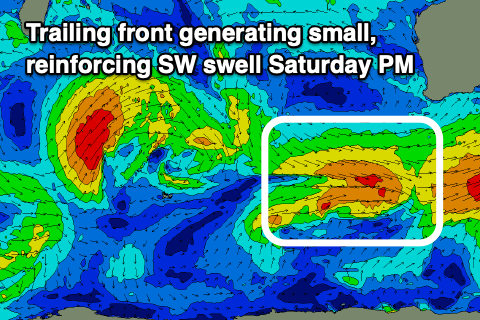
Saturday will become smaller, but a reinforcing pulse of mid-period SW swell is due into the afternoon, generated by a weak trailing front pushing through our swell window late week. 5-6ft sets should hold across Margs all day, 2ft in Mandurah and 1-2ft across Perth, easing from a slightly smaller size Sunday. Winds look favourable for the metro locations again, but possibly light onshore in the South West as the swell producing front clips the state. Margs looks cleaner Sunday with a NE’ly but we’ll confirm this Wednesday.
Longer term we’re looking at a fun run of inconsistent W/SW groundswells with winds from the north-east quadrant but check back Wednesday for more information.