Stormy XL swell for the weekend, large groundswell next week

Western Australia Surf Forecast by Craig Brokensha (issued Friday June 17th)
Best Days: Monday all locations, Tuesday morning for the keen Perth and Mandurah, Thursday morning Perth and Mandurah, Friday morning all locations
Features of the Forecast (tl;dr)
- XL stormy W'ly swell building tomorrow with strong W/NW tending W winds
- Easing XL swell Sun PM with strong SW winds, abating and tending S/SW
- Easing swell Mon with light E/NE-NE tending variable winds in Perth and Mandurah, variable around Margs ahead of weak NW breezes
- Smaller Tue with fresh N/NW winds (NE early in Perth and Mandurah)
- Large W/SW groundswell building Wed PM, easing Thu PM with strong NW tending W winds Wed, SW Thu (SE in Perth and Mandurah)
Recap
Perth offered the best waves yesterday and this morning with surf mostly in the 2ft+ range. Mandurah was more wind affected, choppy today and to 2-3ft, with choppy waves across Margs, becoming stormier as today progressed.
This weekend and next week (Jun 18 - 24)
Bigger, and stormier. That's what we're looking at this weekend with a strong frontal progression now moving in from the west.
This is bringing today's strengthening NW winds which will become even stronger tomorrow while shifting W/NW and then W through the day.
We'll see an extra-large mix of stormy swell developing through the day, likely reaching 12ft+ across the South West, with 3-5ft in Mandurah and 4ft across Perth.
Sunday should see the swell easing back from a similar size and winds will shift SW, strong in the morning before easing a little and tending S/SW later.
Monday was the day to watch out for and it looks like the models have settled somewhere between EC and GFS, with a variable breeze due across the South West, E/NE-NE in Perth and Mandurah as the weekend's swell eases away in size and power.
The South West will be lumpy and raw but improve through the day with light to moderate afternoon W/NW winds. Perth and Mandurah should remain clean most of the day. Easing sets from 8ft+ are due in the South West, 3-4ft in Mandurah and 2-3ft across Perth.
Tuesday will be smaller again but winds will start to freshen from the N/NW across Margs creating poor conditions, NE tending NW across the metro beaches but back to 1-2ft.
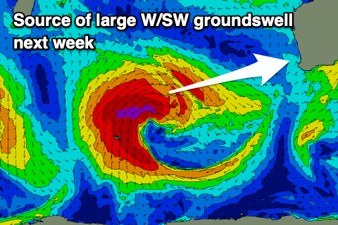 Into Wednesday and Thursday we've got a large W/SW groundswell due, generated by a strong, broad and slow moving low firing up south-east of South Africa, though strongest north of the Heard Island region.
Great fetches of severe-gale W/SW-S/SW winds will wrap around the slow moving low as it pushes slowly east towards us.
This will generate a prolonged, large W/SW groundswell which will arrive strongly Wednesday afternoon and hold Thursday morning.
The South West should reach 12ft+ with strong 4ft sets in Mandurah and 3ft waves across Perth but with strong NW winds, shifting W'ly through the day as the remnants of the progression moves in from the west. SW winds will spoil the easing swell Thursday around Margs, cleaner to the north with a morning S/SE-SE'ly.
Into the end of the week the swell looks to ease with light winds and following this there's nothing major on the cards. We've got weaker mid-period swells. More on this Friday, have a great weekend!