Large, stormy surf developing

Western Australian Surf Forecast by Craig Brokensha (issued Monday June 13th)
Best Days: Perth and Mandurah tomorrow morning and Thursday morning
Features of the Forecast (tl;dr)
- Easing stormy W/SW swell tomorrow with NE tending W/NW winds across Perth and Mandurah (possibly variable in the South West but otherwise W, increasing through the day)
- Building mid-period W/SW swell Wed PM with strong N/NW tending NW winds (lighter N/NE early in Perth and Mandurah)
- Easing W/SW swell Thu with strong N/NW tending NW winds (lighter N/NE early in Perth and Mandurah)
- Large, building storm swell Fri with strong N/NW tending W winds
- XL stormy swell building Sat, easing Sun with strong W/NW winds
- Easing surf Mon with gusty W/SW winds, back to the N/NW Tue
Recap
Average conditions across the South West Saturday with NW winds and a mix of mid-period NW swell and building W/SW groundswell. Perth and Manurah were cleaner and better Saturday morning with a peaky mix of waves to 2-3ft. Yesterday conditions were a touch cleaner in the South West with easing sets from 6-8ft, peaky and fun 2-3ft.
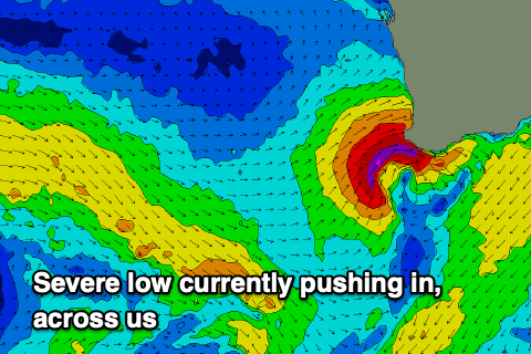
Today a severe low has slammed into the South West bringing large stormy surf to the region, 3-4ft in Mandurah and 2-3ft in Perth.
This week and weekend (Jun 14 - 19)
 As touched on in last week’s updates we’ve got a poor week of surf ahead for the South West as mid-latitude fronts push in from the west, bringing onshore winds but no overly size surf until later week and into the weekend.
Today’s low will clear quickly to the east resulting in improving winds across all locations along with easing levels of localised swell.
Perth and Mandurah should see light NE winds with the South West likely seeing variable breezes, but there’s also a chance for lingering W’ly breezes. Either way the sea state will still be quite agitated and messy with the onshore breezes out to sea.
Mandurah should ease back from 2-3ft (more so 2ft Perth) with Margs easing back from 6ft+. Conditions will deteriorate through the day as winds freshen from the W/NW ahead of the next approaching frontal system.
A low point in swell is due Wednesday morning ahead of some new W/SW energy into the afternoon. Morning N/NE winds will shift N/NW through the day and strengthen across Perth and Mandurah with strong N/NW tending NW winds from the get go across the South West.
Size wise, the mid-period energy for the afternoon doesn’t look significant at all, maybe reaching 4-6ft in the South West, 2ft further north, easing from a similar size Thursday. Winds look similar to Wednesday on Thursday, with Perth and Mandurah worth a morning paddle.
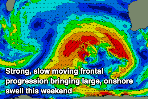 From Friday we’ll see a stronger, slow moving frontal progression firing up to our west, with multiple embedded fronts due to generate strong to gale-force winds while moving slowly east and then across us on the weekend.
Building levels of large mid-period W’ly swell are due Friday along with strong N/NW winds, shifting W’ly through the day. This will also bring some localised windswell with the South West due to build to 8ft+ across the South West with 3ft sets in Perth and Mandurah.
Larger swells should build through the weekend with 12ft+ storm surf due in the South West Saturday afternoon and Sunday morning, 3-5ft in Mandurah and 3-4ft across Perth. There’ll be nowhere to hide though with strong W/NW winds due on Saturday, strong W/SW on Sunday.
Onshore W/SW winds look to linger on Monday as the frontal progression slowly weakens and moves east, with Tuesday seeing a return to fresh N/NW winds and smaller surf. We may see the fronts continuing through next week but the models diverge regarding this so check back here through the week for a clearer idea.