Developing run of onshore, stormy surf

Western Australia Surf Forecast by Craig Brokensha (issued Friday May 10th)
Best Days: Late tomorrow Perth, Tuesday morning Perth and Manduah, Thursday morning Perth and Mandurah
Features of the Forecast (tl;dr)
- Moderate sized W/NW swell building Fri, peaking Sat AM
- Large W/SW groundswell building Sat with strong N tending N/NW, then NW winds (lighter N late around Perth)
- Easing W/SW groundswell Sun with a late increase in windswell. Strong N/NW tending W-W/SW winds
- Large stormy W'ly swell Mon with strong but easing W winds
- Easing W swell with NW winds in Margs, NE Perth and Mandurah
- Similar winds Wed with smaller surf
- Large building W/SW swell with Thu with early NE winds Perth and Mandurah, strong NW Margs
Recap
The inconsistent groundswell seen through Tuesday and Wednesday eased back into yesterday with a reinforcing pulse not really showing well at all across the South West. Winds strengthened from the NE and some small to tiny W’ly swell started to show from the northern flank of the low sitting west of us.
More size is showing today from this source with peaky 2ft sets across Perth and Mandurah with more size towards 3ft due this afternoon under less favourable N/NE winds.
This weekend and next week (Jun 11 - 15)
On Wednesday we were looking at a period of favourable morning winds for Mandurah and Margaret River before the low to our west pushed east and across us but unfortunately this has been pushed forward. This will result in dawn N’ly winds and with a bit of strength, shifting N/NW through the morning and then NW into the afternoon. Perth may see winds go more variable N later and there’ll be mid-period W/NW swell easing from 3ft in the morning.
 Across the South West our inconsistent W/SW groundswell is due to fill in, peaking through the afternoon. This was generated by a strong low in the southern Indian Ocean, generating a fetch of gale to storm-force W’ly winds before splitting in two and weakening.
We should see sets building to 6-8ft across the South West, 2-3ft in Mandurah and 2ft+ across Perth but with those average winds, easing through Sunday with strong N/NW tending W-W/SW winds (N/NE early in Perth).
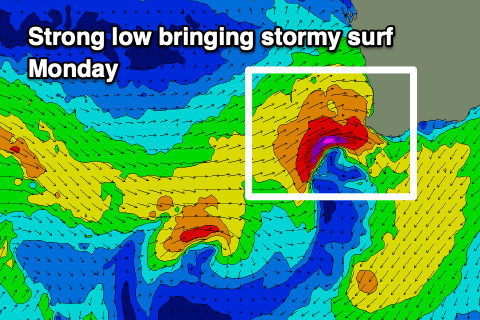
This strong change will be linked to a strengthening mid-latitude low off our coast, with an afternoon increase in localised stormy swell due, peaking Monday morning to 10ft+ across the South West, 4ft in Mandurah and 3ft+ across Perth. Winds will unfortunately remain strong and onshore from the W, abating through the day.
 Lighter NE winds are expected on Tuesday in Perth and Mandurah, NW across the South West with the next approaching frontal system. Swell wise we’ll be seeing W’ly swell from Monday with no quality to be found around Margs, though workable easing 2-3ft sets in Mandurah, 2ft+ across Perth.
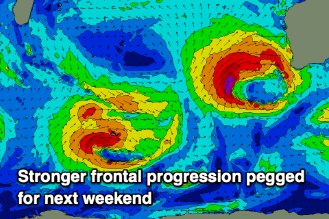
From Wednesday stronger mid-latitude lows and fronts are forecast to fire up west-southwest of us, bringing a run of building stormy onshore surf that looks to set in for the coming fortnight.
We’ll see large, stormy surf building Thursday ahead of surf more near the XL range next weekend but with terrible winds and conditions. Perth and Mandurah may see NE winds Thursday with the first pulse of swell, but come the weekend it looks like all locations will be onshore. We’ll have a closer look at this on Monday. Have a great weekend!