Strong winds and tricky surf

Western Australia Surf Forecast by Craig Brokensha (issued Wednesday June 6th)
Best Days: Protected spots selected breaks tomorrow, Saturday morning ahead of the change in Mandurah and Margs
Features of the Forecast (tl;dr)
- Inconsistent W/SW groundswell tomorrow AM, easing Fri
- Strong E/NE tending NE winds tomorrow, strong NE tending N/NE winds Fri
- Moderate sized W/NW windswell building later Fri, peaking Sat AM
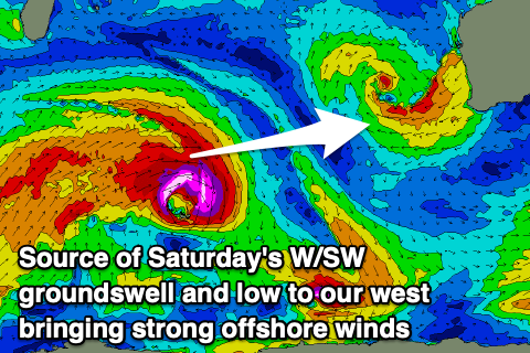
- Large W/SW groundswell building Sat with gusty N/NW tending W/NW winds in Perth through the AM, fresh NE tending W/NW during the PM in Mandurah and Margs
- Easing surf Sun with strong N/NE tending NW winds
Recap
Good though increasingly windy conditions across the South West yesterday with fun sets to 4ft in the morning, building to an inconsistent 6ft through the afternoon with a new long-period W/SW groundswell. Perth and Mandurah were tiny but built a little through the day.
Today we've got stronger offshore winds and inconsistent sets persisting around 6ft in the South West, 1-2ft in Mandurah but only 1-1.5ft in Perth.

Yesterday AM

This morning
This week and weekend (Jun 7 - 12)
We've got a secondary pulse of inconsistent W/SW groundswell due across all locations tomorrow morning and this should provide a bit more energy and consistency to the metro locations.
Infrequent sets more to 1-2ft should be seen in Perth and Mandurah, with 6ft sets across the South West but with the deepening low immediately west of us, winds will become more troublesome and strong from the E/NE tending NE. This will only favour select locations, deteriorating further Friday as the swell eases with strong NE tending N/NE breezes.
This will be as the low starts to move east while weakening, moving in on the weekend bringing N/NW tending W/NW winds to Perth, NE tending W/NW in Mandurah and Margs (delayed into the afternoon for the South West due to the lows centre being closer to that region).
 This will spoil a new, inconsistent W/SW groundswell across the northern regions but there should be workable options in Margs and Mandurah with the morning NE breeze.
This swell has been generated by a strong low firing up south-east of South Africa, generating a fetch ranging between gale to storm-force, with it since breaking down and splitting in half.
We should see a good spike in size on Saturday, kicking to 6-8ft across the South West into the afternoon, 2ft to possibly 3ft in Mandurah and 2ft in Perth. At the same time there'll be some weaker W/NW swell in the mix from the northern side of the low sitting west of us, building Friday and peaking to 2-3ft Saturday morning in Perth and Mandurah.
Easing surf from both sources is due into Sunday but another approaching mid-latitude low will bring strong N/NE tending NW winds through the day.
The low will push across us on Monday bringing strong W tending W/SW winds and a localised increase in stormy windswell.
This unfortunately looks to be the start of a classic onshore, winter frontal progression that will bring increasing onshore winds and building storm swells mostly from late next week and beyond.
There might be windows of cleaner conditions in Perth and Mandurah, namely Wednesday at this stage but we'll take a closer look at this on Friday.
Comments
Lots of rain in the North West. It feels like Queensland. Billions of ravenous killer mozies should thin the crowds out.
Be great time to be camping ......not haha, its either the mozies or no see ums