Great run of surf and offshore winds from Sunday

Western Australia Surf Forecast by Craig Brokensha (issued Friday June 3rd)
Best Days: Sunday, Monday in the South West, Tuesday afternoon through Friday
Features of the Forecast (tl;dr)
- Smaller surf Sat with S/SE tending S/SW winds (E/SE further north early)
- Mod-large SW groundswell for Sun, easing into the PM with light E tending SE winds, back to the E/SE late
- Easing swell Mon with fresh E/NE winds
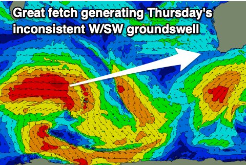
- Inconsistent but strong W/SW groundswell building Tue PM, holding Wed with strong E/NE winds
- Secondary slightly better W/SW groundswell Thu with strong E/NE winds, easing Fri with similar winds
Recap
Poor conditions and average surf in the South West, building through the day with weak, windswelly waves to the north.
Today our better pulse of mid-period W/SW swell has filled in with much better conditions and 6ft+ surf across the South West, 2-3ft in Mandurah and 2ft in Perth. The swell has since started to ease as winds remain favourable.
This weekend and next week (Jun 4 - 10)
Conditions are a little mixed for tomorrow as we see today's swell easing in size, dropping from 4-5ft in the South West and 1ft to possibly 2ft in Mandurah and Perth. Locations north of Margs will see E/SE offshore winds, S/SE across Margs and tending S/SW into the afternoon.
Into the late afternoon our strong pulse of new SW groundswell may be seen but Sunday morning will reveal the peak in size, coming in at a great 6ft+ across the South West (8ft clean ups on the magnets) and 2ft in Mandurah and Perth.
 This was generated mid-week by a strong polar low down near Heard Island and winds will swing back offshore across the South West with a light offshore E'ly (E/SE to the north) shifting SE into the afternoon and back to the E/SE late.
The swell is due to ease into the afternoon, back from a smaller 5ft on Monday morning in the South West with 1-2ft sets further north.
Conditions will remain clean with a fresh E/NE breeze, holding Tuesday but strengthening.
As touched on in Wednesday's notes, the first of a couple of pulses of new, inconsistent W/SW groundswell is due into Tuesday afternoon, with a secondary pulse for Thursday.
 These swells have (and are still) being generated by back to back lows firing up south and south-east of South Africa, with both being similar in strength and size, but the second pushing a bit closer towards us.
The first swell for Tuesday afternoon will be the least consistent with the South West due to build to an inconsistent 6ft+ with infrequent 2ft+ waves in Perth and Mandurah, holding Wednesday ahead of the secondary pulse Thursday to a similar size.
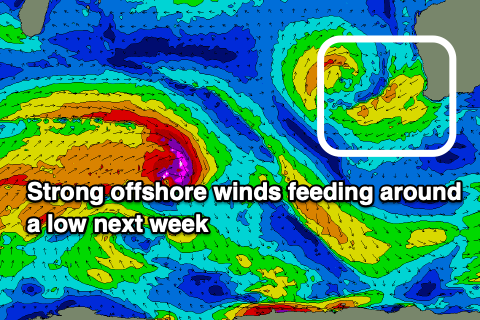
A deepening low to our nwest will see winds strengthen from the E/NE further on Wednesday creating tricky conditions, holding Thursday and Friday before swinging around to the NW on the weekend.
Longer term some new, inconsistent W/SW groundswell is due next weekend with slowly improving winds following the change on Saturday but we'll have a closer look at this Monday. Have a great weekend!