Pick the eyes out of the forecast

Western Australia Surf Forecast by Craig Brokensha (issued Monday May 30th)
Best Days: Tomorrow afternoon in the South West, early Wednesday in the South West, Friday morning, Saturday morning in the South West, Sunday
Features of the Forecast (tl;dr)
- Building mid-period W/SW swell Tue PM with E tending variable NE winds, peaking Wed with NE tending NW and then W winds
- Moderate sized + W/SW swell building Thu PM, easing Fri with fresh SW winds Thu, E/SE tending stronger S/SE Fri
- Small surf Sun with E/SE tending S/SE winds
- Moderate sized + S/SW groundswell for Sun with E winds
Recap
Clean conditions early across the South West Saturday with a drop in swell from the 4ft range while there were small 1-2ft leftovers across Perth and Mandurah.
Yesterday saw some new, weak S/SW swell kicking across all locations, best in Perth and Mandurah, easing through today with the northern regions performing best. Margs is smaller, weak and lumpy.
This week and weekend (May 31 – Jun 5)
Funky.
That's the outlook in a nutshell with mid-latitude fronts and troughs due to bring weak swells and tricky winds this week.
Today's easing energy will fade further tomorrow but with more favourable winds from the E, tending variable NE into the afternoon. Size wise Margs will be small, weak and fading from 3ft max on the sets across the magnets (2-3ft mostly), tiny in Perth and Mandurah.
The afternoon should provide a few more options with the arrival of an infrequent, new mid-period W/SW swell.
This was generated by a distant but broad low firing up south-east of South Africa last week and we should see sets building to 3-5ft late in the day, peaking Wednesday to 4-5ft+ on the exposed reefs. Perth and Mandurah should see tiny 1-1.5ft waves but winds will be an issue with an early NE breeze due to shift NW and then W during the day. Get in early for the best conditions.
 This change will be linked to a weak trough clipping the state bringing fresh SW winds Thursday along with a new pulse of mid-period W/SW swell through the afternoon and Friday morning.
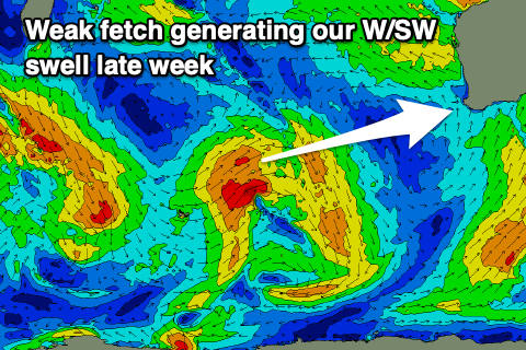
This swell is being generated by a weak fetch of strong to sometimes gale-force W/SW winds pushing east through the southern Indian Ocean, but all in all it's not overly special.
Larger surf to 6ft+ is due across the South West Thursday afternoon and Friday morning, 2ft in Mandurah and Perth on the sets.
Friday looks the pick as winds shift back to the E/SE during the morning ahead of stronger afternoon S/SE breezes. Similar winds are expected on Saturday but with smaller surf.
 Later Saturday afternoon some small new mid-period S/SW swell may be seen in Margs, but A better S/SW groundswell is due Sunday.
The source of this swell will be a funky polar low forming around the Heard Island region mid week. A short-lived fetch of gales should produce a spike of swell to 5-6ft+ across the South West, 2ft in Mandurah and Perth. The models are combining swells and over-forecasting the size so keep that in mind.
Favourable all day offshore E winds should make it worth penciling across the exposed breaks.
Longer term the there's some more promising, stronger Southern Ocean storm activity on the cards later this week and beyond, generating larger groundswells for mid-next week and the following weekend. More on this Wednesday.