Average outlook with windows next week

Western Australia Surf Forecast by Craig Brokensha (issued Friday May 27th)
Best Days: Early tomorrow in the South West for the keen, Tuesday across all locations (Perth and Mandurah PM), early Wednesday all locations, next weekend
Features of the Forecast (tl;dr)
- Easing SW swell Sat with early SE tending strong S/SW winds (E/SE further north early)
- Moderate sized + S/SW swell building Sun with strong S tending S/SE winds later
- Easing S/SW swell Mon with fresh S/SE winds
- Building mid-period W/SW swell Tue PM with E winds, peaking Wed with NE tending fresh N/NW winds
- Moderate sized + W/SW swell building Thu with fresh SW winds, easing Fri with S/SE winds
- New swell next weekend with favourable winds (at this early stage)
Recap
A new pulse of mid-period SW swell through yesterday maintaining 2ft sets across Perth and Mandurah, with building surf to 5-6ft in the South West as offshore winds ironed out conditions through the day.
Today is similar if not a touch smaller with clean conditions across all locations and great waves between 4-6ft in the South West, 2ft in Mandurah and 1-2ft across Perth.


Great surf yesterday in the South West
This weekend and next week (May 28 – Jun 3)
Compared to the last two days, the weekend isn't too flash with the current swell due to continue to ease as winds deteriorate owing to a strengthening polar front projecting up towards us.
An early, light SE breeze is due tomorrow morning, shifting strong S/SW later morning as the front pushes in. Expect leftover 4ft sets for the keen on the exposed reefs early, tiny to the north.
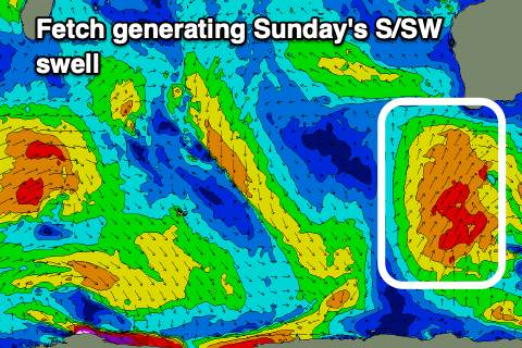 Looking at the polar front and overall it looks a little weaker and less favourable for swell generation (not that it was great in the first place), with building mid-period S/SW swell expected through Sunday, reaching 6ft+ across the exposed breaks in the South West, 1-2ft in Mandurah and Perth though more windswelly.
Conditions will be poor at these exposed breaks with a strong S'ly wind, tending S/SE later in the day but protected spots will be tiny.
Fresh S/SE winds will persist into Monday as the S/SW energy eases, leaving not real quality options out of the wind.
A high moving in from the west early next week should swing winds around to the E on Tuesday with a slow start size wise ahead of an inconsistent new mid-period W/SW swell.
This swell and a secondary for Wednesday were generated by a broad but distant low that developed south of South Africa earlier this week. While inconsistent it should provide 4-5ft+ sets across the South West, tiny in Perth and Mandurah.
Winds Tuesday afternoon at this stage look variable E, worth a late session with NE tending fresh N/NW winds on Wednesday, so try and surf early.
The shift in winds will be associated with a slow moving and persistent low moving in from the west-southwest, bringing with it some fun, new mid-period W/SW swell Thursday.
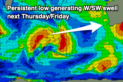 This low will form off the back of the system linked to Tuesday afternoon and Wednesday's swell, with a fetch of strong to gale-force W/SW winds moving through the southern Indian Ocean from now until early next week.
Size wise 6ft to occasionally 8ft sets are due in the South West through the afternoon Thursday, 2-3ft in Mandurah and 2ft+ across Perth but with SW winds in the wake of a change overnight Wednesday.
Winds should revert back to the S/SE on Friday as the swell eases back from 6ft+ and 2ft respectively, cleaner Saturday but also smaller.
Into next weekend a new SW groundswell is due to fill in, but size wise it's still a little uncertain so check back here on Monday for more details. Have a great weekend!