Fun waves from mid-week, windy and cold from Sunday

Western Australia Surf Forecast by Craig Brokensha (issued Wednesday May 4th)
Best Days: Wednesday morning, Thursday, Friday (protected spots PM), early Saturday in the South West
Features of the Forecast (tl;dr)
- Large W/SW groundswell today, easing tomorrow but replaced by weaker, localised W/SW swell, easing through the day
- Strong SW winds tomorrow
- Easing mid-period W/SW-SW swell Wed with variable E/SE-SE morning winds in the South West, light E/NE in Perth and Mandurah during the AM
- Moderate sized + mid-period SW swell for Thu and Fri with light E/NE winds Thu AM (weak sea breezes) and SE tending strong S/SE winds Fri
- Easing SW swell Sat with early E/SE tending strong SW winds
- Large S/SW groundswell building Sun with strong S/SW winds, easing Mon with strong S-S/SW winds
Recap
Good surf across the South West on the weekend with a kick in new swell and favourable conditions Saturday morning, favourable also yesterday morning with a bit more north in the wind. Mandurah was best Saturday and to 1-2ft, bumpier yesterday with similar sized sets while Perth was fun and clean each morning.
Today the remnants of a strong mid-latitude low has moved in bringing strong onshore winds and a mix of new, large W/SW groundswell and localised NW windswell.
This week and next (May 24 – Jun 3)
The large surf currently breaking across the state is thanks to a strong, northward tracking low that developed late last week and pushed east over the weekend while weakening.
The remnants of the low is pushing across us bringing the strong onshore winds and stormy surf, and we'll see the tail of the low continuing to bring strong to gale-force onshore winds overnight tonight, easing and tending strong SW tomorrow.
The swell will become more windswelly with the groundswell easing during this evening, with stormy 8ft waves easing across the South West, 3-4ft in Perth and Mandurah.
 Winds should improve on Wednesday and tend variable E/SE-SE across the South West, light E/NE in Perth and Mandurah as the swell eases further in size, dropping back from 4-5ft across the South West, 2ft on the sets in Mandurah and Perth.
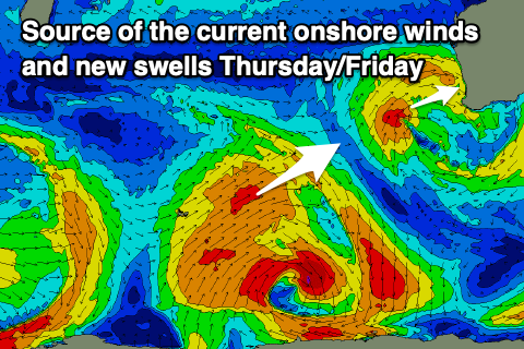
Some new mid-period SW swell is expected to fill in on Thursday with a secondary pulse Friday, generated by a patchy polar low that formed around the Heard Island region yesterday. Patchy fetches of strong to gale-force W/NW followed by W/SW winds have been generated, with back to back swells Thursday and Friday due to come in at 5-6ft across the South West, 2ft in Mandurah and 1-2ft across Perth with light E/NE winds on Thursday morning ahead of weak sea breezes and SE tending stronger S/SE winds Friday.
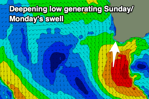 The start of the weekend looks slow with a drop in swell due Saturday but with favourable, early morning E/SE winds deteriorating as a strengthening polar frontal system and low push up and towards us from the south. This will see winds strengthen from the SW and shifting S/SW into Sunday as an elongated fetch of gale to severe-gale S/SW winds are aimed towards us.
The fetch will be aimed mostly into the south of the state and won'y be ideal for swell generation across Perth and Mandurah, but we're probably looking at building, windy surf to the 8ft range across the South West Sunday afternoon, 2ft in Mandurah and 1-2ft across Perth later.
Unfortunately winds will persist out of the S'th as the swell eases through Tuesday next week as the storm forms into a broad, slow moving low in the Bight. We may even see a secondary polar system pushing up mid-next week, bringing another dose of S/SW swell and S/SW winds. We'll have to have a closer look at this on Wednesday.