Tricky, troughy period

Western Australian Surf Forecast by Craig Brokensha (issued Friday May 6th)
Best Days: Tomorrow morning in the South West, Monday morning in the South West, Tuesday morning all locations, Wednesday morning Perth and Mandurah
Features of the Forecast (tl;dr)
- Inconsistent mix of W/SW and SW swells building Sat with early E/NE tending NW winds while freshening, lighter N/NW into the PM
- Reinforcing SW swell Sun AM with N/NW tending fresh W/NW-W/SW winds
- Building mid-period SW swell Mon PM with E/NE-NE tending NW winds
- Stronger mid-period SW swell Tue with NE tending NW winds
- Easing surf Wed with strengthening W/NW tending S/SW winds
- Moderate + sized SW swell Thu/Fri with strong S/SW winds Thu and stregnthening W winds Fri
- Likely large SW groundswell next weekend
Recap
Windy though clean and easing surf yesterday with 4-5ft sets across the South West magnets, 1-2ft in Mandurah and tiny across Perth. This morning the swell is bottoming out and winds are less favourable, strong from the NE.
This weekend and next week (May 7 - 13)
We’ve got an uptick in new swell due tomorrow that being a mix of W/SW and SW energy from a patchy though healthy frontal progression during this week. This swell and a reinforcing SW swell for Sunday morning, generated on the backside of the progression should provide some fun waves in the South West, though mostly tomorrow with deteriorating winds and conditions Sunday.
The first pulse should build to 4-5ft across the South West tomorrow (a touch undersized early) with building surf to 1-1.5ft in Mandurah, 1ft across Peth.
Winds will be best early and moderate E/NE, quickly shifting NE while freshening and then weaker N/NW into the evening.
Sunday’s swell should see the odd bigger set in the South West, with surf to 4-5ft+, tiny further north but winds look average with an approaching trough bringing early N/NW tending fresher W/NW breezes, W/SW into the afternoon. To the north conditions will be cleaner but the swell tiny.
Winds should ease into Monday morning leaving variable breezes across the South West, E/NE-NE through the morning, shifting NW through the day but with easing surf from the 4ft range in the South West, tiny to the north.
Now, moving into the rest of the week we’ve got our varying pulses of mid-period W/SW swell from a flurry of mid-latitude frontal systems between Heard Island region and us.
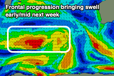 We’ve seen an initial, strong polar low west of the Heard Island region weakening, then projecting north-east up into the southern Indian Ocean. This is being followed by a burst of W/NW gales today with yet another front strengthening to our south-west Sunday, in our south-west swell window.
There’s one final polar front in the mix generating a final swell for Thursday/Friday but this will be hard to distinguish under onshore winds and cold fronts.
Coming back to the first pulse which is due Monday afternoon and sets to 6ft are due in the South West, 1-2ft in Mandurah and 1-1.5ft across Perth with Tuesday’s being a touch stronger and to 6ft+ with 2ft sets in Perth and Mandurah.
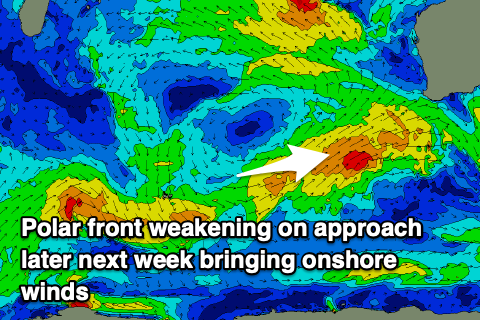 Winds look workable Tuesday morning and NE tending NW, but come Wednesday, strengthening W’ly winds will create poor conditions across the South West, cleaner to the north early in the morning. This change will be linked to a weakening polar front merging with the remnants of a tropical cyclone in the Indian Ocean, bringing strong S/SW winds into Thursday and then W/SW winds Friday as another frontal system projects up towards us.
This will spoil our reinforcing swells into the end of the week but on the positive side looks to bring a large SW groundswell next weekend. More on this tricky period on Monday. Have a great weekend!