Easing surf, new swells for the weekend

Western Australia Surf Forecast by Craig Brokensha (issued Wednesday May 4th)
Best Days: Mandurah and the South West tomorrow, Margs Saturday and Sunday morning, Tuesday morning all regions, early Wednesday all regions
Features of the Forecast (tl;dr)
- Easing surf tomorrow with strong E tending E/NE, then weaker NE winds
- Strong E/NE tending NE and then weaker N/NE Fri with small leftovers
- Inconsistent mix of W/SW and SW swells building Sat with NE tending N winds
- Reinforcing SW swell Sun AM with NE tending fresher W/NW-W/SW winds
- Building mid-peirod SW swell Mon PM with moderate W winds in the South West, NE tending variable Perth and Mandurah
- Stronger mid-period SW swell Tue and Wed AM with morning NE winds Tue, strengthening N winds Wed
Recap
Our extra-large mix of mid-period and stronger, long-period SW groundswell filled in through yesterday with raw though good conditions in protected spots across the South West, similar further north with winds out of the south. Margs hit 10-12ft with 3-4ft sets into the afternoon across Mandurah and 2-3ft in Perth.
This morning the swell is on the ease with great, clean 8ft surf across the South West, 3ft in Mandurah but unfortunately smaller and back to 2ft in Perth. All day offshore winds are creating great conditions as the swell continues to ease.

Pumping
This week and next (May 5 - 13)
Down, down, down.
The current swell will continue to fade over the coming days, with the South West offering the best waves as Perth becomes tiny tomorrow and Mandurah eases from 1-2ft. Margs should still see 4-5ft sets on the magnets, smaller elsewhere and strong E tending E/NE winds should ease from the NE into the afternoon.
Friday will see strong E/NE tending NE winds and then lighter N/NE into the afternoon but fading 2-3ft leftovers in the South West.
Winds on the weekend will hang from the NE each morning, though tending less favourable W/NW and then W/SW on Sunday as a trough moves in from the west.
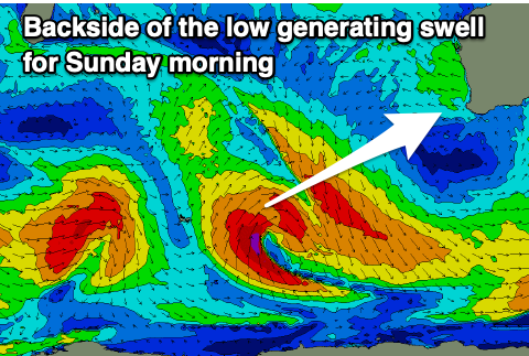 Swell wise, a mix of new W/SW and SW swell are due to fill in Saturday, generated by that poorly structured mid-latitude frontal progression mentioned in Monday's notes.
Sets to 4-5ft are due across the South West with tiny 1-1.5ft sets max in Mandurah, tiny in Perth with those NE tending N winds. A reinforcing pulse of SW swell from the backside of the progression looks a touch stronger, possibly 4-5ft+ in the South West early, easing through the day with tiny 1-1.5ft sets across Mandurah but with those deteriorating winds. Go the early.
We've got some fun, mid-period W/SW swell due into early to mid next week across the state following a progression of fronts between us and the Heard Island region.
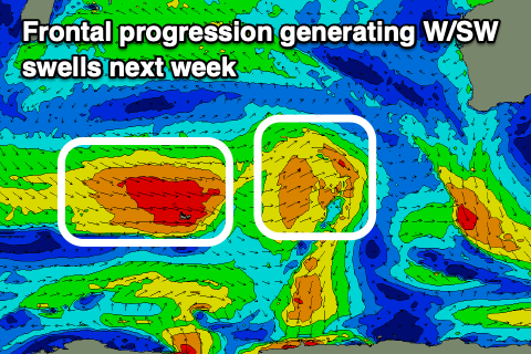 Size wise the first pulse of swell for Monday afternoon should build to 6ft, holding Tuesday with a few bigger sets in the mix. Mandurah should build to 1-2ft, 1-1.5ft in Perth with Tuesday seeing 2ft sets across both Perth and Mandurah.
Winds in the wake of Sunday afternoon's change look to ease but will linger from the W across the South West, lighter NE in Perth and Mandurah ahead of weak sea breezes
Tuesday looks fun in the South West with NE tending NW winds, E/NE in the morning to the north.
Another reinforcing pulse of mid-period swell should keep the surf up into Wednesday morning, easing ahead of one final pulse of moderate sized+ mid-period swell late week.
Winds are tricky though with strengthening N'ly breezes on Wednesday as a tropical cyclone drops down from the Indian Ocean, possibly then turning extratropical off our coasts bringing a large, windy onshore swell later week. We'll have to review this again on Friday though.