XL swell tomorrow, pumping Wednesday

Western Australia Surf Forecast by Craig Brokensha (issued Monday May 2nd)
Best Days: Protected spots tomorrow, Wednesday when winds ease, Thursday in the South West and Mandurah, Saturday morning in the South West, Sunday morning in the South West
Features of the Forecast (tl;dr)
- XL SW groundswell building tomorrow, peaking into the PM with moderate E/SE-SE tending gusty S/SE winds (SE Perth and Mandurah in the AM)
- Easing SW groundswell Wed with strong E/SE winds, abating into the PM
- Easing surf with strong E/NE tending weaker NE winds Thu, strong E/NE tending weaker N/NE winds Fri
- Inconsistent mix of W/SW and SW swells filling in Sat with NE tending W/NW winds
- Similar sized surf Sun with E/SE tending SW winds
Recap
Great surf Saturday with a drop in swell from Friday's large pulse, back to the 6ft range across the South West with 2ft+ sets in Mandurah and 2ft waves across Perth. Sunday was much smaller and best across the South West magnets, tiny to the north.
Today there's a new mix of SW and S/SW groundswells in the water but with onshore winds across the South West, cleaner and 1-2ft to the north (1-1.5ft Perth)
This week and weekend (May 3 - 8)
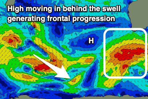
All eyes are on the extra-large SW groundswell due across the state tomorrow, with the frontal progression linked to it currently passing under us, bringing the change in winds to the South West.
This progression started as a strong polar low (west of the Heard Island region), with a fetch of severe-gale to storm-force W/SW winds projecting slowly east-northeast while weakening. Severe-gales continued, with a weaker fetch of gales generated south-west of us this morning before pushing further east.
The slow movement and continued broad fetch have generated a very large, open ocean sea state with the size due to build rapidly through tomorrow.
We'll see a mix of mid-period and long-period SW swell energy building through tomorrow, arriving mid-late morning and building rapidly to 12ft+ across the South West, 4ft in Mandurah and 3ft+ across Perth.
 Locally winds will start to improve and be offshore from the SE-E/SE through the morning in the South West (SE in Perth and Mandurah) with S/SE breezes into the afternoon. Exposed breaks will be a bit raw with protected spots fairing best.
Wednesday looks excellent with a strong (though tricky) E/SE offshore wind, abating through the day but holding into the afternoon with large, easing 10ft surf across the South West, 3ft+ in Mandurah and 2-3ft in Perth.
The strong offshore winds will be linked to a strong high moving in from the west, putting a block on our swell windows, resulting in a continued downwards trend in surf through the end of the week but with favourable, strong E/NE tending moderate NE winds Thursday, similar Friday but more N/NE into the afternoon.
Size wise Perth and Mandurah will be small to tiny Thursday, with fading 4-5ft sets in the South West, smaller Friday.
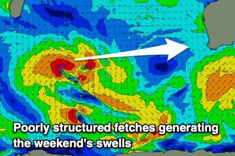 On the weekend a small to moderate sized mix of W/SW and SW swell are due off a poorly aligned mid-latitude progression of lows, north of the Heard Island region. A small fetch of W'ly gales will be followed by NW gales, with a small kick to 3-5ft due across the South West magnets through Saturday, tiny further north.
Winds will be NE ahead of a trough and onshore W/SW change. So surf early.
The weak nature of the trough should see winds swing back offshore on Sunday morning with similar sized sets to Saturday.
Longer term the models diverge a little but we've got some better swell potential for the following week but winds look a bit dicey with the storm generating swells pushing up and into us. More on this Wednesday.
Comments
Nice. Cheers Craig.
This all seems like a carbon copy of last years comp. Building through the day, peaking late, a bit wild on the day of the swell, then cleaning up and still big and clean on the following day before the arse drops out of it. Still looks a little too south for The Point to properly pick up the most energy of it but definitely gonna be bombing. Your updates have been spot on. Yew!
Thanks BD!
please Craig Whats the direction of the swell for up mid north west Craig? South south west or SW? thanks
Probably between SW and SSW.
Any confirmation if the wozzle can hold the comp at NP, if so does anyone know the limit on how long into the arvo they can run?. Keep getting mixed info..
Spewing if they take over the first swell there in ages.
Not sure sorry Leif.
Not sure if they got the enviro permit, council and boardriders both endorsed it for Northies. 8 hours max per day.
Oh wow the Tuesday synoptic. Some epic waves had in similar forecasts.
let them out at big offshore pumping mains