Tricky period though improving from Friday

Western Australia Surf Forecast by Craig Brokensha (issued Monday April 25th)
Best Days: Today in the South West out of the wind, Friday morning, Saturday morning, Sunday morning in the South West, protected spots early-mid next week
Features of the Forecast (tl;dr)
- Mix of moderate sized + swells tomorrow with strong W/NW-W winds, easing and tending variable on dark
- Mix of moderate sized + swells Wed with fresh to strong S/SW tending SW winds
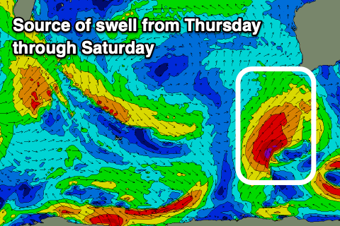
- Mod-large mid-period SW swell building Thu with fresh S/SW winds, tending S/SE later
- Mod-large mid-period S/SW swell Fri with a stronger groundswell into the PM with E/SE tending SW winds
- Easing S/SW groundswell Sat with E tending SW winds, smaller Sun with E tending SW winds
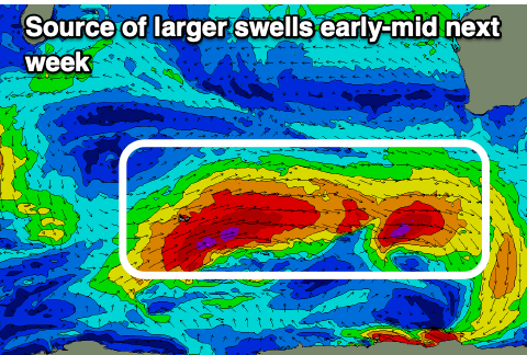
- Large swells for early-mid next week but with winds unknown for now
Recap
Flat conditions in Perth and Mandurah with a slow, inconsistent swell for the magnets in the South West Saturday, fading from 2ft yesterday morning.
Today started a little slow but our new W'ly groundswell has since started to kick with less than favourable, strong NE winds, now slowly easing as the swell builds further. We should see the South West reaching 6ft+ with a variable N/NE breeze, then tending NW and strengthening on dark. Winds will shift W/NW across Perth and Mandurah spoiling any increase in size.


Building swell with windy conditions
This week and weekend (Apr 26 – May 1)
The coming period is tricky due to some slight model divergence regarding mostly the incoming swell producers late week and into next week.
Firstly though, a trough moving in from the west will bring an onshore change tomorrow morning, with poor, onshore conditions due to dominate in its wake this week as a progression of cold fronts and lows push up and into the state.
Strong W/NW-W winds are due tomorrow morning, easing into the afternoon and going variable on dark as a mid-latitude low projecting towards us pushes up and across the north of the state.
It'll be a weakening mid-latitude low come trough with a mix of swells in the 6ft range across the South West and 2ft further north though with those poor winds.
 Winds will increase from the S/SW shifting SW through the day on Wednesday as we fall in behind the trough pushing up and across us tomorrow, with a shift back to the S/SW on Thursday as a polar front come deepening low pushes up from the south-west, shifting S/SE later.
This low will generate a healthy fetch of gale to possibly severe-gale S/SW winds in our southern swell window on Thursday, with some mid-period S/SW swell due to build Thursday afternoon ahead of some better groundswell on Friday afternoon.
The models diverge slightly regarding the positioning and strength of this fetch with ECMWF looking smaller and weaker. With this though a high will move in quicker on Friday, bringing more favourable E/SE winds, though with the south swell direction it won't be great.
At this stage it looks like we'll see surf coming in around 6-8ft across the South West, 2ft in Mandurah and Perth but with that morning offshore and weak afternoon sea breezes.
Easing surf is expected Saturday from around 6ft+ in the South West, 2ft further north along with light morning E/SE winds, shifting SW into the afternoon.
 Sunday looks smaller but clean again in the morning with light offshore winds, while late in the day a strong new SW groundswell may be seen.
The models diverge on the low generating this swell, with it forming ahead of a strong frontal system later this week, north-east of the Heard Island region. Either way we should see a large pulse of SW groundswell for Tuesday/Wednesday in the 8-10ft range across the South West with a possible 6ft+ pulse on Monday.
Winds at this stage are tricky, with a trough due to bring some sort of change early next week, forming into a possible low south-east of us. This looks to bring strengthening winds from the south-eastern quadrant but we'll have to review all of the above in Wednesday's notes. The take home message is that conditions won't improve until late week.