Tricky weekend winds with the most size

Western Australia Surf Forecast by Craig Brokensha (issued Friday April 8th)
Best Days: Tomorrow morning all locations, Perth and Mandurah Sunday morning, Monday morning, Tuesday through Thursday mornings in the South West
Features of the Forecast (tl;dr)
- Steadying mid-period SW tomorrow with mod S/SE tending SW winds
- Inconsistent SW groundswell Sun with strong W/SW tending fresh S/SW winds in the South West, light E/NE tending SW in Perth and Mandurah
- Easing SW groundswell Mon with SE tending SW winds (S/SE Perth and Mandurah in the AM), smaller Tue with E tending S/SW winds
- Small, inconsistent SW swells Wed and Thu with morning E winds
Recap
Good surf yesterday morning across the South West with clean conditions and a new, building mid-period swell from 4-5ft with tiny waves across Perth and Mandurah, building into the afternoon as winds shifted more north.
Today winds were light and conditions clean and good across Perth and Mandurah with 2ft sets, while Margs saw favourable conditions in protected spots with 4-6ft sets. Since, a trough has brought an onshore change to all locations.
This weekend and next week (Apr 9 - 15)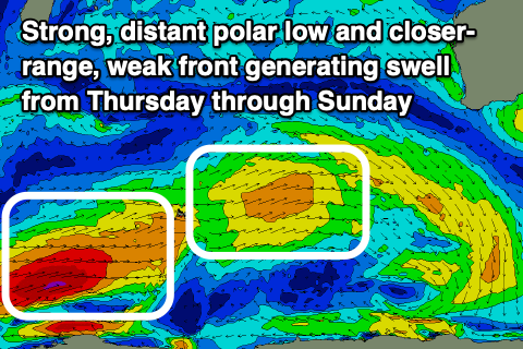
Today's trough will push east ahead of a secondary trough on Sunday with winds tending S/SE tomorrow morning before shifting back to the SW tomorrow afternoon along with some reinforcing, mid-period SW swell.
Size wise the South West should hang around 4-6ft with 2ft sets in Perth and Mandurah with protected spots fairing best in the morning. Our stronger SW groundswell on Sunday still looks to be spoilt by strong W/SW tending S/SW winds in the South West, with Perth and Mandurah performing best with early variable E/NE winds.
This groundswell, generated in our far swell window should provide more size and strength with 6ft to occasionally 8ft sets developing during the day in the South West and 2ft in Perth and Mandurah.
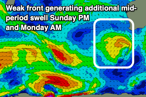 Into Sunday afternoon and Monday there'll be some moderate sized, mid-period S/SW swell from the trough responsible for the onshore winds pushing up and into us. This will ease with the groundswell on Monday from 4-6ft in the South West and 2ft across Perth and Mandurah with more favourable, lighter SE for a period in the South West and S/SE to the north.
Tuesday will become smaller but cleaner on the exposed breaks, best suited to the South West magnets with an E/SE offshore ahead of sea breezes.
Moving into Wednesday and conditions will be clean again but the surf small with the models combining a small, background SW groundswell with existing energy and over-forecasting the size. It'll likely only be around 3ft to occasionally 4ft in the South West (tiny Perth and Mandurah), similar Thursday.
Longer term the outlook remains slow with moderate sized, mid-period swells due to keep the South West active, but we'll have another look at this Monday. Have a great weekend!
Comments
Hi Craig,
Great shots from Manly. I have a long standing query:
why are the primary swell forecasts so overcooked? (eg, currenlty the rottnest bouy says 2.0m yet the SN forecast says 2.8-2.6) I've noticed the SN forecast are consistently 0.5-1m larger than the actual bouy reading.