Great run of offshore winds and fun surf

Western Australia Surf Forecast by Craig Brokensha (issued Friday March 4th)
Best Days: The South West tomorrow and Sunday mornings, Tuesday and Wednesday mornings in the South West
Features of the Forecast (tl;dr)
- Fun SW groundswell tomorrow with mod-fresh E/SE tending strong S/SW winds
- Easing SW swell Sun with mod-fresh E tending strong S/SW winds, smaller Mon with strong E/SE tending S/SW winds
- New mid-period SW swell Tue with fresh-strong E/NE winds and weaker sea breezes, easing Wed with similar winds
- Easing surf into the end of the week with E/NE tending W/SW winds
- New SW swell Saturday with E tending S/SW winds
Recap
Easing surf with slightly better winds across the South West yesterday morning but best in protected spots, cleaner today and a fun 3-4ft. Perth and Mandurah were a peaky 1-1.5ft yesterday, cleaner today and holding a similar size.
This weekend and next week (Mar 5 - 11)
Into this afternoon we should see a bit more energy showing across the state as a new mid-period SW swell fills in but this will be the precursor to a larger SW groundswell tomorrow morning.
The source of these swells was a favourable polar frontal progression with tomorrow's largest pulse generated by a strong polar low. This should provide good 5-6ft sets across the South West magnets tomorrow morning with 1-1.5ft sets in Mandurah, tinier across Perth.
The swell is due to ease through the afternoon and become smaller into Sunday, dropping from 4-5ft.
 Winds look ideal tomorrow and moderate to fresh from the E/SE ahead of strong S/SW sea breezes, great again Sunday and moderate to fresh from the E ahead of similar strong S/SW sea breezes.
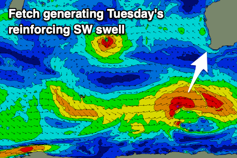
Monday looks a touch smaller again and back to 3ft+ along with stronger E/SE morning winds, while a new, reinforcing mid-period SW swell is due to fill in Tuesday.
This will be generated be a polar low forming east of the Heard Island region tomorrow, with a brief fetch of strong winds generated before it pushes east and under the country.
A fun kick back to 4-5ft is due across the South West magnets but Perth and Mandurah will remain tiny and to 1ft.
Winds will again be great owing to a stubborn high pressure system setting up under us with fresh to strong E/NE winds ahead of weaker sea breezes, similar Wednesday as the swell eases.
 Smaller surf is due through Thursday and Friday with persistent morning E/NE winds.
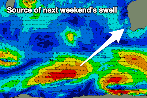
Longer term high pressure will continue to dominate our swell windows into next weekend and early the following week, with another moderate sized, mid-period SW swell on Saturday.
Beyond this smaller surf is due into the week of the 14th with a possible better swell later in the week. More on this Monday. Have a great weekend!