Fun surf options this period

Western Australia Surf Forecast by Craig Brokensha (issued Wednesday February 9th)
Best Days: Tomorrow morning in the South West, early Friday, Sunday morning, Monday morning, Tuesday morning in the South West
Features of the Forecast (tl;dr)
- Inconsistent SW groundswell building tomorrow with fresh SE tending E/SE winds ahead of strong S/SW breezes, peaking Fri with S/SE tending S/SW winds (N/NE tending N/NW and then SW to the north)
- Easing SW swell Sat with S/SE tending S/SW winds
- Reinforcing SW swell Sun with E/SE tending SW wind
Recap
Monday's messy conditions improved markedly through yesterday with lighter winds and easing 4-6ft sets across the South West, a fun 2ft+ in Mandurah and 2ft across Perth.
Today the swell has cleaned up further across the South West with easing sets from the 4ft range, 1-2ft in Perth and Mandurah.
This week and next (Jan 10 - 18)
Moving into the end of the week we've got great conditions tomorrow with our new, inconsistent SW groundswell due to fill in through the day, followed by a reinforcing pulse of energy on Friday which will provide the most size.
The source of these swells was a strong, slow moving polar low pushing through our swell window since Sunday, with some trailing activity now due to produce additional mid-period swells into the weekend.
 Looking at tomorrow though and winds will swing offshore through the morning from the SE to E/SE and remain favourable until about midday when sea breezes kick in. It'll be inconsistent but building sets to 5-6ft on the magnets are due through the day in the South West (smaller at dawn), 2ft on the sets into the afternoon across Mandurah and 1-2ft in Perth but with the sea breeze,
Friday morning should offer a bit more size with 5-6ft+ sets in the South West as Mandurah and Perth hold a similar size to the afternoon before. Winds will be OK early and S/SE shifting S/SW across Margs with Perth and Mandurah seeing N/NE tending N/NW winds ahead of a fresh SW change as a trough moves through.
This will unfortunately leave lingering SW winds into Saturday across the South West, S/SW to the north as the swell eases temporarily.
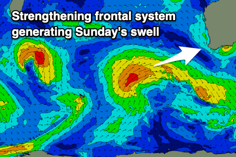
Later in the day but more so Sunday a new mix of mid-period swells are due, the first from the SW, linked to weaker trailing polar frontal activity mentioned above, while some better W/SW swell will be generated by this activity projecting up and towards us through Friday and Saturday.
This secondary intensification should generate a moderate to large W/SW swell which will start to build late Saturday and peak Sunday afternoon to 6-8ft in the South West, 2-3ft in Mandurah and 2ft+ across Perth.
Winds look to improve rapidly Sunday as the front clears quickly to the south-east, bringing E/SE offshore winds ahead of strong sea breezes.
Monday also looks clean as the swell starts to ease.
Longer term a strong polar low looks to generate another good pulse of SW groundswell for later next week but more on this Friday.