Good week of surf, slower into the weekend

Western Australia Surf Forecast by Craig Brokensha (issued Monday November 22nd)
Best Days: Every morning this week (Perth and Mandurah tomorrow and Wednesday), the South West Saturday morning
Features of the Forecast (tl;dr)
- New mid-period SW swell for this afternoon, holding early tomorrow
- Stronger W/SW groundswell filling in through the day, peaking through the afternoon with light E/SE tending strong SW winds
- Easing W/SW groundswell Wed onwards with light morning E/SE winds (E Friday morning) and afternoon sea breezes
- Small, weak W/SW swell Sat AM with light E/SE winds ahead of sea breezes
Recap
Clean conditions each morning on the weekend but small, fading surf in the South West Saturday, tiny to the north.
This morning there was a little hint of new swell but with unfavourable conditions, bigger this afternoon but a mess.
This week and weekend (Nov 23 - 28)
After the run of small to tiny surf we've finally got a bit more swell and waves to play with over the coming week.
Looking at tomorrow and we'll see a mix of mid-period SW swell that is currently building across the South West, mixed in with a larger building W/SW groundswell, peaking into the afternoon.
 The mid-period energy was generated by distant, patchy though healthy frontal activity south-east of Madagascar late last week, while the stronger groundswell was generated by a closer frontal system projecting W/SW gale to severe-gales through our swell window yesterday, weakening today.
The South West should build to 6-8ft through tomorrow, 2ft+ in Mandurah and 2ft across Perth on the sets. Winds will improve from today, easing and tending light SE across all locations in the morning ahead of gusty SW sea breezes.
The swell should start easing Wednesday but will likely be a similar size early in the day (if not a touch smaller across the South West) along with a light to moderate E/SE offshore wind, and strong S/SW-SW sea breezes.
Thursday will become smaller and with a moderate E/SE offshore ahead of sea breezes. The easing trend will be slowed a touch by weak, reinforcing levels of mid-peri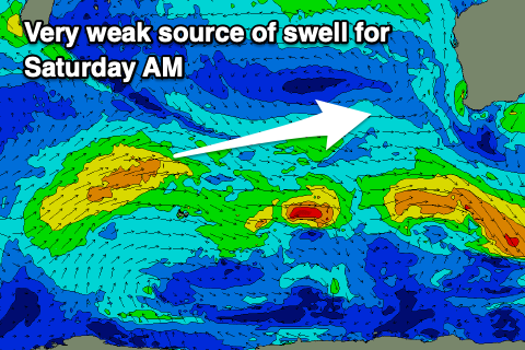 od swell, but it won't prevent the swell becoming small Friday with morning E/SE-E winds.
Into Saturday, a small pulse of weak W/SW swell is due, generated by a weak front projecting briefly towards us today, north of the Heard Island region. Don't expect anything above 3-4ft in the South West, tiny further north but nice and clean through the morning again.
Longer term there's nothing significant on the cards but there is a little bit of potential with instability being drawn south from the north, possibly providing the catalyst for some stronger storm activity. More on this in the coming updates.
Comments
The first tropical cyclone of the Australian season has developed, but it won't last long or be a swell producer.
Tropical Cyclone Paddy.

It's been a while..