Poor weekend, better options next week

Western Australia Surf Forecast by Craig Brokensha (issued Friday November 19th)
Best Days: Tuesday morning protected spots, Wednesday morning, Thursday morning in the South West protected spots
Features of the Forecast (tl;dr)
- Fading S/SW swell tomorrow with moderate E/NE winds ahead of sea breezes
- Small, weak SW swell for Mon with S/SW winds
- Better, inconsistent SW swell building Tue with morning S/SE winds ahead of sea breezes
- Stronger W/SW groundswell Wed with E/SE tending S/SW winds
- Easing surf Thu with stronger SE winds
Recap
A tiny lift in swell across all locations yesterday, windy and average in the South West, cleaner in Perth and Mandurah but tiny.
Today conditions are cleaner in Margs with a slightly better, mid-period S/SW swell to 2-3ft, tiny and bumpy in Mandurah with 1-1.5ft sets across Perth.
This weekend and next week (Nov 20 - 26)
The slight bump in swell seen today will fade tomorrow but conditions will be clean across all locations with a moderate E/NE offshore, NW and then SW across the South West into the afternoon, with fresher SW sea breezes to the north.
Sunday morning will start with early light offshore winds ahead of a trough and strengthening S/SW-S breezes into the afternoon.
This will be linked to a weakening front moving in from the west, bringing a small, weak increase in SW windswell Monday. This has been downgraded further with weak sets to 3-4ft due in the South West, tiny in Perth and Mandurah.
Winds will remain average in any case and out of the S/SW on Monday, reverting back to the S/SE on Tuesday morning ahead of sea breezes, even better Wednesday with an E'ly offshore in the South West.
 This will be when our better pulse of swell fill in. The first which is due to build through Tuesday will be mid-period energy from strong though distant frontal activity, south-east of Madagascar earlier this week.
This should see surf building to an inconsistent 5-6ft in the South West through the afternoon and 1-2ft in Mandurah and Perth, but a larger pulse of better groundswell has now been brought forward to Wednesday.
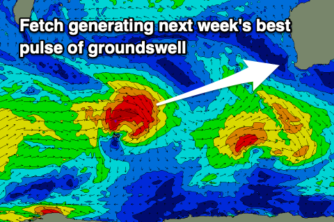
The source of this swell will be a great fetch of gale to severe-gale W/NW winds moving east-southeast through our swell window today and through the weekend.
The east-southeast track isn't ideal but the strength of the fetch should see a good pulse of swell peaking Wednesday morning to 6ft to occasionally 8ft across the South West, 2ft in Mandurah and 1-2ft in Perth.
This will be that favourable morning offshore wind and afternoon sea breezes.
A drop in size is due through Thursday as winds revert back to the SE and blow strong. Friday looks great conditions wise but the swell will be small and on the way out.
Longer term, besides a small, reinforcing pulse of SW swell for Saturday things look slow again with relatively weak and benign frontal systems firing up through our swell window. Therefore make the most of next week's swells. Have a great weekend!