Large swells with mostly onshore winds

Western Australia Surf Forecast by Craig Brokensha (issued Friday August 27th)
Best Days: Perth and Mandurah tomorrow, protected spots Thursday, Friday morning
Features of the Forecast (tl;dr)
- Inconsistent, large W/SW groundswell for tomorrow AM, easing. Light NE tending NW winds in Perth and Mandurah, mod-fresh W/SW around Margs
- Small surf Sun with strong W/SW winds
- Large, building mid-period SW swell Mon PM with strong W/SW winds
- Large SW groundswell building late Tue, peaking Wed AM with strong NW winds Tue and strong NW tending W/SW Wed
- Easing SW groundswell Thu with fresh S-S/SW winds
- Reinforcing large W/SW swell Fri with possible early variable winds
Recap
A low point in swell and onshore winds across all locations yesterday, strengthening through the day and today we've got a large new mid-period W/SW swell with strong onshore winds in the South West, more workable and cross-onshore in Perth and Mandurah for the keen.
This weekend and next week (Aug 28 – Sep 3)
The frontal progression linked to the current onshore winds and mid-period swell will move off to the east through tomorrow, with the groundswell component of the swell filling in tomorrow morning.
This should keep the surf up around the 8ft range across the South West, 3ft on the sets in Mandurah and 2ft+ across Perth.
Conditions look favourable for Perth and Mandurah with variable NE winds, but the lingering nature of the swell generating front under our coast today will unfortunately see moderate to fresh W/SW winds continuing across the South West. Perth and Mandurah will see weak afternoon NW winds.
Unfortunately Sunday will see onshore winds kick back in across all locations ahead of a vigorous polar frontal progression starts pushing up and into us.
Strong W/SW winds are due to move in before dawn, persisting Monday with a touch more strength.
Swell wise there's nothing of strength of power due until the afternoon Monday but more so Tuesday/Wednesday.
Looking at the progression and we'll see an initial elongated front project W/SW gales through our south-western swell window tomorrow and Sunday, followed by a broader, stronger front, projecting W/SW gales more through our southern swell window.
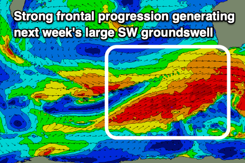 This will see a mid-period SW swell building Monday ahead of a larger SW-S/SW groundswell on later Tuesday/Wednesday. Size wise the largest kick on Wednesday should reach 10-12ft across the South West, 3-4ft in Mandurah and 3ft on the sets across Perth. Winds are still a major issue though and strong from the NW on Tuesday as a third polar front projects up and into the eastern Indian Ocean.
There's a chance for early N/NE winds in Perth and Mandurah but we'll review this Monday.
Come Wednesday when the most size is due winds look to remain strong from the NW, giving into an afternoon W/SW change as the high latitude front pushes in from the west.
This looks to bring a S-S/SW change on Thursday, but not truly offshore so protected spots will be the best with the easing SW-S/SW groundswell from the 10ft range across the South West, 3ft in Mandurah and 2-3ft across Perth.
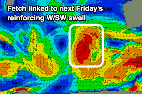 A ridge of high pressure will temporarily slide in for Friday, swinging winds more offshore across all regions (likely SE in the South West and E/NE to the north) but another approaching front looks to push this north, bringing weak onshores back to the South West next Saturday.
A reinforcing W/SW groundswell is due off the high-riding front, coming in at 8-10ft in the South West Friday, 3ft across Mandurah and keeping 2-3ft waves in Perth. We'll look at the local winds again on Friday regarding any window of offshores across the state.
Longer term besides a smaller, reinforcing SW swell on the weekend, it looks like we'll see continued, weaker storms moving through our swell window into the start of September. More on this Monday. Have a great weekend!