Poor couple of days, better from the weekend

Western Australia Surf Forecast by Craig Brokensha (issued Wednesday July 14th)
Best Days: Saturday all locations, Perth and Mandurah Sunday morning, Monday all locations, Tuesday morning all locations
Features of the Forecast (tl;dr)
- Large, stormy W/SW swell Thu with strong-gale force SW winds, easing slowly later
- Easing W/SW swell Fri with strong, easing S/SW winds
- New, long-period SW groundswell Sat with light, variable winds, tending W/NW into the afternoon
- Easing SW swell Sun with NE tending W/SW-SW winds in Perth and Mandurah, W/NW in the South West
- Reinforcing SW swell Mon with variable, offshore morning winds, easing Tue with strengthening E/NE tending NE winds
Recap
Large, stormy and poor surf across all locations yesterday as the swell from a strong, high-riding mid-latitude low pushed in, abating today in both size and wind strength as the low pushed slowly east.
This week and next (Jul 15 - 23)
Currently, a vigorous and strengthening frontal system is projecting up and into us from the south-west, with it due to make landfall this evening, bringing strong to gale-force W/SW-SW winds across all locations, swinging SW tomorrow morning and backing off slightly through the afternoon.
With the front will come a large, stormy swell across all locations with the South West expected to jump back to 12ft+ across the South West, 4-5ft in Mandurah and 4ft across Perth.
As the front pushes east into the evening we'll see the surf start to ease, with dropping sets through Friday along with strong, though easing S/SW winds.
The weekend is still looking cleaner and much better for a surf with variable winds due across all locations Saturday morning (with a NE tendency), shifting W/NW into the afternoon.
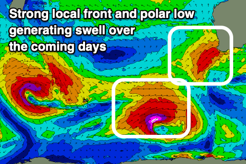 We'll also see a new, long-period SW groundswell in the water, generated by a strong polar low firing up east of the Heard Island region.
A great fetch of severe-gale to storm-force W/SW winds will be generated through our south-western swell, with the swell upgraded slightly from Monday. Strong 10ft surf is due in the South West, 3ft+ across Mandurah and 2-3ft in Perth, easing through the day.
Sunday is now looking average across the South West with a weak trough bringing moderate W/NW winds as the SW groundswell eases. Perth and Mandurah should see early NE winds, shifting W/SW-SW into the afternoon but without too much strength. Size wise Mandurah looks to ease from 2ft+, with 1-2ft sets in Perth.
A small, reinforcing SW swell is due into the afternoon and Monday as winds improve. The source will be a strong to gale-force W/NW fetch moving through our swell window behind tomorrow's front with the South West coming in around 6ft, 2ft in Mandurah and Perth.
The swell should ease from a similar size on Tuesday but with strengthening E/NE tending NE winds as the next mid-latitude storm starts to push in from the west.
This mid-latitude low and fronts behind it unfortunately look to spoil some larger, better long-period groundswell due into next week, but we'll look at this closer Friday.