Large swell tomorrow with workable winds

Western Australia Surf Forecast by Craig Brokensha (issued Friday May 28th)
Best Days: Later today all locations protectedspots, tomorrow for keen surfers, protected spots Sunday morning, Tuesday through Thursday mornings in the South West
Features of the Forecast (tl;dr)
- Large W/SW groundswell kicking later today, peaking Sat with varying workable winds (see below)
- Easing W/SW groundswell with developing strong S/SE-S winds Sun, tending S/SW into the afternoon, easing further Mon with strong S/SE winds
- Inconsistent SW groundswell pulse for Tue with light morning offshore winds, similar Thu with NE tending N winds
Recap
Yesterday's new pulse of inconsistent SW groundswell wasn't really present at all with just a slight pulse of new energy with strengthening offshore tending north winds across Margs. Mandurah and Perth saw a tiny, peaky NW windswell.
Today there's a bit more energy in the water with workable 3-5ft waves in the South West, 1-2ft in Mandurah and still a tiny 1-1.5ft in Perth.
This weekend and next week (May 29 – Jun 4)
Later today we should see our large W/SW groundswell starting to fill in, with the mid-latitude low linked to it, currently weakening south-west of us.
Over the past couple of days a good fetch of gale to severe-gale W/SW winds were projected towards us, with the swell due to kick to 8-10ft by dark today in the South West, 2ft to maybe 3ft in Mandurah and Perth. Winds will be strong from the N across the South West, N/NE to the north while tomorrow should see the swell peaking to 10-12ft+ across Margs, 4ft in Mandurah and 3-4ft across Perth.
Winds will be a slight issue, shifting W/NW-W/SW across the South West though only moderate and there's an outside chance for a period of variable winds at dawn, with fresh N/NE tending weaker W/NW and then W winds in Perth and Mandurah.
 With this there should be options across all locations for the keen and not fussy.
Sunday will see strong S/SE-S winds develop across the South West, lighter and more variable for a period in Perth and Mandurah before shifting strong S/SW later morning.
The swell will be on the ease, dropping from the 8ft range in the South West, 2-3ft further north in Mandurah and 2ft+ across Perth.
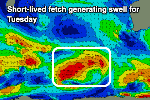
Unfortunately winds will persist out of the S/SE on Monday as a weak mid-latitude low forms off our South Coast and with the further drop in swell it'll be marginal. Cleaner conditions should be seen Tuesday along with a small bump in mid-period SW swell.
The source of this swell will be a short-lived polar front, generating a burst of W/SW gales this afternoon through tomorrow. Size wise we're only looking at sets t 4-5ft+ across the South West but with a SE-E/SE breeze, it'll be worth a surf. Mandurah and Perth look tiny.
Wednesday looks clean again but smaller ahead of a new, inconsistent SW groundswell late in the day but more so Thursday.
The source of this swell is a patchy fetch of W/NW-NW gales, so don't expect anything major size wise with it likely only coming in at an infrequent 4-5ft again across the South West magnets with a NE tending N breeze.
Longer term we may see a broader and more significant polar low firing up south-west of us late week, generating a larger S/SW groundswell for next weekend, but we'll have to look at this in more detail on Monday. Have a great weekend!