Tricky winds with building swell activity

Western Australia Surf Forecast by Craig Brokensha (issued Monday May 17th)
Best Days: Wednesday, Thursday, Monday morning protected spots in the South West, early Perth and Mandurah
Features of the Forecast (tl;dr)
- Easing surf tomorrow with a weak S'ly change
- Mix of swells building Wed with light, variable E/SE winds in the AM, easing Thu with morning E-E/NE winds
- Larger, mid-period W/SW swell building Sat with fresh onshore winds
- Easing swell Sun with stronger onshore winds
- Large, long-period SW groundswell for Mon with onshore winds, cleaner Tue AM
Recap
Small, clean surf to kick off the weekend, better Sunday with a new swell and great conditions in the South West. Today the swell was on the ease and winds strengthening from the north ahead of a change.
This week and weekend (May 18 - 23)
Coming in cold off a couple of weeks break the outlook for the coming days is a little hazy. Ben had the surf continuing to ease through tomorrow and we'll see a trough bring a S'ly change to the South West early tomorrow morning, with variable winds around Perth and Mandurah.
With no real size it looks to be mostly a lay day.
We should see a fun new mix of groundswells fill in Wednesday, generated by a good frontal passage east of the Heard Island region over the weekend. One final low that's currently west-southwest of us will add some additional energy to the mix with building surf to what Ben forecast last week. 5-6ft sets are due in the South West with no major size to the north, maybe 2ft+ across Mandurah and 1-2ft in Perth.
Winds should be better and light, variable E/SE across all locations Wednesday morning ahead of weak sea breezes, moderate E-E/NE on Thursday ahead of weak sea breezes as the swell eases from a little less size.
The surf looks to bottom out into the end of the week and a trough will bring light W/NW winds to the South West, strengthening through the day, though with more variable breezes to the north but with no size.
Come the weekend a mix of mid-period W/SW swells are due to fill in though again there'll be no real size or strength to these. Winds will be also an issue as a weakening polar low pushes up and into us.
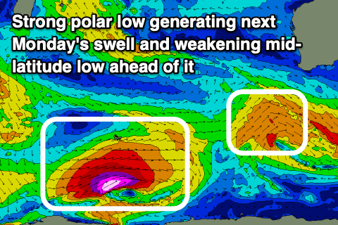 The mid-period swell will be generated by a persistent but not overly strong mid-latitude low moving through the southern Indian Ocean this week. A fetch of strong to gale-force W/SW winds will be aimed through our western swell window before the low weakens while passing under us Friday, bringing those onshore winds.
Size wise the South West should build to 6ft+ with 2-3ft sets in Mandurah, 2ft across Perth. Winds will be onshore in the wake of the trough moving through before dawn Saturday, bringing S/SW winds to the South West, W/SW tending SW further north.
Sunday will start smaller but with strong W/NW tending S/SW winds as the remnants of the weakening polar low pushes up into us.
While bringing poor conditions, we'll see a large SW groundswell generated by the earlier stages of the low, with a fetch of severe-gale to storm-force W/SW winds projected nicely through our swell window from the Heard Island region.
The swell should arrive overnight Sunday and peak Monday to a large 10ft+ across the South West, 3-4ft in Mandurah and 3ft on the sets across Perth. The models are combining localised mid-period energy with the groundswell Monday and over-forecasting the size so keep this in mind.
Conditions look to remain poor with strong S/SW winds across the South West Monday, variable early to the north in Mandurah and Perth but not quite across to Rottnest Island. Tuesday morning should offer cleaner though not ideal conditions with early light N winds as the swell eases steadily.
Longer term there's plenty of frontal activity and on the cards for the rest of the week, but winds are a little touch and go. More on this Wednesday.
Comments
Thanks Craig, so what’s this mean for the Rottnest Island event? Ok sideshore waves Wed, clean & small Thurs & then a big swell to trigger the north side of the island early next week?
Yeah possibly run tomorrow arvo if they're keen but more likely Thursday, then Saturday could be a goer as well as Sunday morning. It's gonna be a play it by ear scenario with all these tricky winds and windows of lighter, cleaner conditions. Tuesday/Wednesday look like clean good days with Tuesday the pick.
Oh and they can only surf Strickland from what I'm aware of.
Patto + one of the connected guys on lipped podcast said Stark Bay was backup. Don’t know if the WSL ever confirmed it though
surely they'll run TUES-WED? Random question Craig - why is the bouy reading always so much smaller than forecast (eg, rottnest bouy says 0.97m but predicted to be 1.9m)? Have meant to ask for years now...
Yeah I’m interested in that too? (there’s so many different forecast models). Tuesday May 18th:
1.0m DoT Rottnest swell bouy
1.9 m Swellnet Forecast
1.1m Seabreeze (Perth)
0.9-1.4m Magic Seaweed (Strickos)
1.2m Windy app (Strickos)
0.9m Surf-forecast.com (Strickos)
I must say I find Swellnets “Forecast notes” the most accurate.
Yep I think Patto was right, it sounds like the other breaks are an option - From WSL ... “ Often considered a toned-down Margaret's, the WSL will focus its attention here (Strickland Bay) with prospective backup sites on the north side of Rottnest at the unadulterated bombie of Stark Bay - "a left-hand tube fest when it's on", Williams exclaims - and the much-coveted yet notorious Rotto Box to the west.”
https://www.worldsurfleague.com/posts/471183/a-look-at-rottnest-island-t...