Large surf easing over the weekend; another large swell next week

Western Australian Surf Forecast by Ben Matson (issued Saturday 8th May)
Features of the Forecast (tl;dr)
- Large swell today, easing Sun, with generally OK conditions
- Smaller surf Mon thru' early Wed
- Large swell due overnight Wed, peaking Thurs, with a chance for winds to swing E/SE
Recap
Thursday came in a little smaller than expected, generally holding 6ft sets across the Margs region with a couple of rare bombs pushing 6-8ft, and conditions were clean through the morning with offshore winds ahead of a mid-afternoon onshore change. Perth and Mandurah were generally small and average. Wave heights eased into Friday and winds came up from the south, limiting conditions. It’s currently pre-dawn across the WA coast right now (about 5am WA time) but the Cape Naturaliste buoy is showing the expected new groundswell nicely - up in size from Thursday’s swell - and winds are light and variable so conditions should be clean.
This weekend (May 8 - 9)
This morning’s new swell is really the centrepiece for the weekend. And although we haven’t got visual confirmation on it yet, the buoy data is inline with forecast expectations, so we should be looking at set waves in the 8ft to maybe 10ft range at times across the Margaret River coastline.
A weak front will clip the coast through the day, sending winds to the SW and freshening a little, so bumpy conditions are likely after lunch. Prior to then the morning should deliver very good conditions.
Perth and Mandurah will probably reach peak through the afternoon, around 2-3ft and 3-4ft respectively (expect smaller options early morning, as the swell is still on the build). The front won’t really impact anywhere north of Bunbury however weak sea breezes are possible.
Wave heights will ease back into Sunday, and similar conditions will persist across the state with another front clipping the state. e may see a period of early light winds but for the most part expect light to moderate SW breezes across the Margs region, light and variable with weak sea breezes north of Bunbury.
As for size, we’ll be on the backside of Saturday’s event and so exposed Margs breaks are likely to ease from 6-8ft to 4-6ft through the morning, becoming less consistent too. Expect a similar trend across the metro beaches, easing from 2ft+ and 3ft+ in Perth and Mandurah respectively.
Next week (May 10 onwards)
The first half of next week is looking at smaller, slower conditions thanks to a break in the storm track over the last few days. A ridge of high pressure will generate light winds on Monday but freshening-pre-frontal northerlies are likely Tuesday ahead of a gusty S’ly change on Wednesday. As such Monday is the pick across exposed coasts with easing 4-5ft sets at the reefs and open beaches. It'll be pretty small across metro coasts by this time.
Wednesday’s change will be linked in with a powerful Southern Ocean low that’s already developing south of Madagascar (today) and will undergo further intensification over the coming days as it tracks eastward (see below).
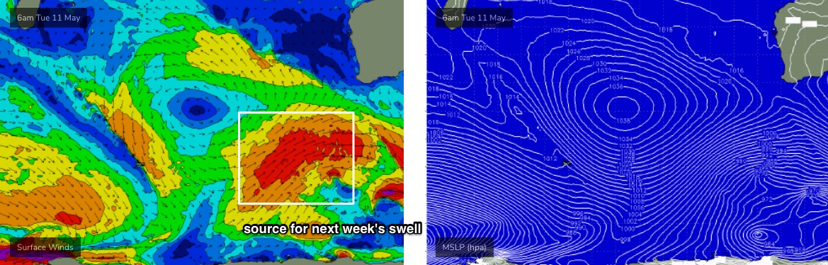
The resulting groundswell is pegged to arrive across the lower SW region late Wednesday afternoon and will build overnight towards a peak on Thursday, with size pushing north of 10ft at exposed spots across the Margs region.
There’s also a suggestion that conditions may improve rapidly in the wake of Wednesday’s front, with the models hinting that a surface trough may pinch off the broadscale Long Wave Trough as it approaches West Oz early next week, and then stall well to the west of the WA coast at about Geraldton latitudes - resulting in an E/SE inflow across the SW WA coastline for Thursday. Let’s take a closer look at that on Monday.
The long term trend beyond Thursday’s swell will be heavily influenced by this Indian Ocean trough, which may steer the Southern Ocean storm track away from our region temporarily - but there’s a whole bunch of storms backing up further west with stacks of potential for the long term.
Have a great weekend, see you Monday!
Comments
Hi Ben, any idea when subscribers will be able to read the next available forecast notes ?
In about an hour!