Good swell filling in this week, worth making the most of

Western Australia Surf Forecast by Craig Brokensha (issued Monday 2nd November)
Best Days: Wednesday, Thursday morning, Friday morning protected spots in the South West, Saturday
Recap
Bumpy, easing surf through Saturday, starting slow Sunday morning with onshore winds continuing at first light in the South West, cleaner to the north.
Winds tended variable through the day creating improving conditions with a building W/SW groundswell which is now on the ease today with bumpy 6ft+ waves across the South West, cleaner and to 2-3ft in Mandurah and Perth.
This week and weekend (Nov 3 - 8)
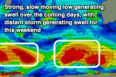
Our current swell from the strong low that formed to our west on the weekend will fade into tomorrow as a large, new long-period SW groundswell fills in in its place.
This was and is still being generated by a strong, slow moving low that formed in the Heard Island region, producing a slow moving fetch of W/SW gales. It's still producing a very healthy fetch of W/SW gales in our southern swell window, prolonging the swell event this week.
We should see the swell building tomorrow, though peaking Wednesday with 6-8ft+ waves across the South West, 3ft on the sets in Mandurah and 2ft to occasionally 3ft across Perth.
 Winds tomorrow still look average as we fall under the influence of the backside of the low that's currently moving across us, bringing strong S/SW winds across the South West, slightly better to the north and S/SE early before shifting SW.
Wednesday onwards still looks great as a strong high moves in, swinging winds fresh offshore out of the E/SE, likely only S/SE-S into the afternoon and then strong but easing E Thursday ahead of afternoon sea breezes.
The swell should be on the ease Thursday out of the S/SW with sets dropping from the 6ft range across the South West, 2ft+ in Mandurah and 2ft in Perth, smaller Friday with strong and less than ideal SE winds.
The next swells due into the weekend and next week will spread up from persistent but not overly strong or well aimed polar frontal activity through our south-western and southern swell windows.
The first for the weekend will be generated by a fetch of pre-frontal turning W'ly gales around the Heard Island during the coming days, building Saturday and peaking Sunday morning with sets to 4-6ft across the South West, 1-2ft in Mandurah and 1-1.5ft across Perth.
Saturday at this stage looks mostly clean but windy, with a trough bringing a S'ly change for Sunday, but we'll have to look at this in more detail Wednesday.
Following this smaller swells with lingering winds out of the south are likely, but more on this in the next update.