Not great tomorrow, much better days to follow

Western Australia Surf Forecast by Craig Brokensha (issued Monday 21st September)
Best Days: Perth and Mandurah tomorrow morning for the keen, Wednesday, Thursday, Friday morning
Recap
A poor weekend of surf with strong to gale-force onshore winds, terrible weather and large, developing storm surf.
Today the surf is still poor and onshore with large waves to 8ft across the South West, while Perth and Mandurah have seen more variable winds and better, though lumpy and to 2ft around the former, 3ft on the latter.
This week and weekend (Sep 22 - 27)
As per the last couple of updates, the swell from the weekend's low will continue to ease through tomorrow, but the slow moving nature of the system will see winds linger onshore and out of the SW across the South West, but only light. There may be periods of more variable breezes, but keep your expectations low.
Perth and Mandurah should see variable winds in the morning but onshore breezes right up until dawn will leave lots of lump to the swell.
Size wise we'll be looking at easing 1-2ft sets across Mandurah, 1-1.5ft in Perth and 4-5ft or so across Perth.
Wednesday's new W/SW groundswell is on track, with it due to build through the day as better winds develop across all locations.
The source of this swell was a strong but slightly poorly constructed low moving in from west of Heard Island, but weakening around that region in our medium-range swell window.
The swell should build to a fun 6-8ft across the South West through Wednesday, 2ft to maybe 3ft across Mandurah and 2ft in Perth. Winds will swing around to the E/SE across all locations in the morning as a high slips in from the south-west, giving into afternoon sea breezes.
Stronger and tricky E'ly winds are on the cards for Thursday as a surface trough drifts south from the Indian Ocean, squeezing the high along with easing swell from 6ft+, 2ft+ and 2ft respectively across the regions.
 As the trough continues to move south and the high drifts east, we'll see winds shift more E/NE into Friday (remaining strong) but easing a little into the afternoon. There's no new swell due with the South West magnets the pick.
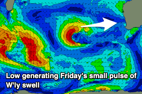
A small pulse of W'ly swell should be seen across the metro regions Friday, generated today and tomorrow morning by a small mid-latitude low sitting west of us. The low will be better aimed towards Indonesia, but a slight kick to 2ft is due in Perth and Mandurah on the sets, small across the South West and to 3-5ft.
The weekend isn't expected to offer any real surfing opportunities with Friday's fleeting pulse of W'ly swell due to fade as winds swing onshore from the NW tending W Saturday, W/NW-NW Sunday.
This will be associated with a mid-latitude front slowly edging in from the west, bringing with it a mid-period W/SW swell for early next week.
The fetch strength is weak but it'll be prolonged, with a moderate to large W/SW swell on the cards.
We're probably looking at messy, onshore surf around 8ft or so across the South West, 2ft in Mandurah and 2-3ft across Perth.
Winds will only improve later week and by this stage the swell will be gone. More on this Wednesday though.
Comments
The new swell is in!
So... let's head out in a kayak?