Large, easing surf but work the winds

Western Australia Surf Forecast by Craig Brokensha (issued Monday 14th September)
Best Days: Tomorrow, protected spots for the keen Wednesday morning, South West magnets Thursday, Saturday morning protected spots in the South West, Sunday in the South West
Recap
A drop in swell and onshore winds across the South West Saturday, much better in Perth (2ft) and Mandurah (3ft) with great conditions.
A large new long-period SW groundswell filled in yesterday with great conditions across the South West, good in Perth and Mandurah but a little smaller, with today looking excellent across all locations. Margs was 8ft, Mandurah 2-3ft and Perth 2ft but a new pulse of SW groundswell has since produced a little more size again this afternoon.
This week and weekend (Sep 14 - 20)
After the recent days of large SW groundswell we'll see the surf ease through this week, with the next significant swell due on the weekend.
This will be after the largest spike in SW groundswell this afternoon and tomorrow, though from the more distant source highlighted in Friday's notes, resulting in it being less consistent.
We should see the South West building to 8-10ft, easing from a similar size tomorrow morning, 3ft in Mandurah and 2ft to occasionally 3ft across Perth.
Winds won't be as favourable and shifting more SE tomorrow morning, favouring southern ends of beaches and coves, and shifting more S'ly into the afternoon (S/SW around Perth and Mandurah).
 Wednesday looks more limited again regarding surfing options with the swell easing further under fresh and gusty S/SE tending S/SW winds.
Winds are due to swing back offshore on Thursday but they'll be strong and out of the E/NE. Swell wise it looks small with leftover 3-4ft waves in the South West, tiny to the north.
Friday will be even smaller as the surf bottoms out with strengthening NE tending N winds.
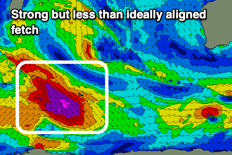
Moving into the weekend and a fun new SW-S/SW groundswell is on the cards, generated by a pre-frontal fetch of gale to severe-gale NW tending W/NW winds moving in ahead of a low that will push along the polar shelf over the coming days.
While not ideally aimed, the strength, breadth and longevity of the fetch should produce a good moderate sized S/SW groundswell to the 6ft range in the South West (likely odd bigger one). Mandurah may see slow 1-2ft sets, tiny in Perth and to 1ft.
A trough moving through Friday evening will bring a shift in winds to the S/SE on Saturday, better Sunday but stronger and out of the E/SE as the swell eases.
Following this there's nothing too significant on the cards with clean conditions and moderate sized swells due next week (mid-late) but more on this Wednesday.