Winter's set to return

Western Australia Surf Forecast by Craig Brokensha (issued Friday 31st August)
Best Days: Perth and Mandurah Friday and Saturday mornings
Recap
Plenty of size Saturday but average conditions across the South West, much better Sunday and pumping with clean conditions and 6-8ft of groundswell. Mandurah was a lumpy but fun 3-4ft on Saturday with clean 3ft waves Sunday, a touch smaller to the north both days.
Today winds have shifted more north and with a low point in swell across the South West, clean and 2ft in Mandurah and Perth. We should see a significant kick in XL W/SW groundswell later today across the South West but with deteriorating conditions as wind strengthen from the west.
This week and weekend (Sep 1 - 6)
Later today's W/SW groundswell should reach 15-18ft+ across the South West by dark with 4ft sets in Mandurah and 3ft waves across Perth but with strengthening onshore winds as the remnants of the storm linked to the swell moves into us.
This will kick up an additional increase in windswell tomorrow with similar sized surf due across all regions but with strong W/SW winds, easing a touch later in the day.
As touched on in Friday's notes, unfortunately this whole period will see a return to onshore winds and large to extra-large stormy swells owing to a couple of strong nodes of the Long Wave Trough moving in from the west.
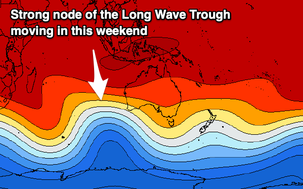 This will bring front after front after front in from the west and south-west, with the strongest node of the Long Wave Trough moving in this weekend set to bring slower moving and broader systems and the most size from Sunday through early next week.
Coming back to Wednesday and strong W/SW winds will persist as the size remains large owing to a polar low that's currently east of Heard Island projecting up and into us. This will generate poor mid-period and windswelly energy ahead of the groundswell energy Thursday afternoon, easing Friday.
There's no let up in the onshore winds even for Perth and Mandurah with moderate to fresh W/SW breezes persisting Thursday.
Friday morning looks to finally offer a window of cleaner conditions with a morning NE breeze across Perth and Mandurah, shifting NW through the day, remaining onshore from the W/NW across the South West. Size wise Mandurah is likely to be around 3ft, 2-3ft in Perth.
Saturday looks to offer similar winds and similar sized surf with a reinforcing W/SW swell from a tight low pushing in from the west tomorrow evening and Wednesday morning.
From Sunday we'll see a broad and slow moving mid-latitude frontal progression moving in, with rotating fetches of strong to gale-force W/SW winds around a couple of embedded lows.
This will bring large, windy, onshore building surf from Sunday through Tuesday with the size likely to peak around 15ft or so in the South West, 4ft in Mandurah and 3ft in Perth.
Following this activity a more solitary polar front may generate another large groundswell for later next week as winds possibly ease. More on this Wednesday though.