Better waves from mid-late next week

Western Australia Surf Forecast by Craig Brokensha (issued Friday 14th August)
Best Days: Today, Wednesday Mandurah and Margs, Thursday, Friday
Recap
A slight improvement in the surf yesterday across the South West, though still bumpy and lumpy, better to the north with cleaner conditions and 2ft waves across Mandurah, 1-2ft in Perth.
Today conditions were much cleaner across the South West with great surf and 5-6ft sets on the exposed reefs, 1-2ft across Mandurah and Perth. Winds have started to shift more north so make the most of the current conditions before the onshores really set in.

This weekend and next week (Aug 15 - 21)
Moving into tomorrow, similar amounts of swell are due across the state but conditions will be poor with a strengthening N/NW tending NW breeze in the South West, N/NE at dawn in Perth and Mandurah but small and shifting more N-N/NW through the day.
This will see some junky N/NW windswell building, while come Sunday a strong S/SW change will move through as the mid-latitude low linked to the winds moves in from the west and across us.
 Now, the strength and structure of the low has fallen halfway between what EC and GFS were forecasting. It's not a trough but also not an overly well structured mid-latitude low.
It will kick up a stormy increase in size for Sunday to 3-4ft across Perth, 3-5ft Mandurah and 6-8ft+ or so across Margs.
Secondary polar fronts pushing up and into us look to generate additional levels of mid-period S/SW swell Monday through Wednesday and the slow moving nature of the low east will continue direct strong onshore SW winds into us. Monday will see these poor conditions, as will Tuesday as winds shift a little more S/SW, with Wednesday likely seeing offshore winds kick back in across all locations. We'll be seeing SE breezes in the South West and E/NE further north.
Size wise though we should see easing sets from 6ft+ across the South West, only 2ft across Mandurah and 1-1.5ft in Perth.
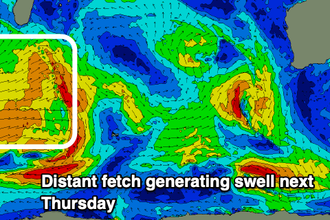
Into Thursday an inconsistent W/SW groundswell is expected, though the source is a bit patchy and not overly strong and distant. A mixed fetch of strong to gale-force W/SW winds will be projected towards us, generating a fun kick in size Thursday.
Margs should see 4-6ft sets, though inconsistent with 2ft sets across Mandurah and Perth. Conditions look nice with a light E/NE offshore, variable into the afternoon with similar conditions Friday as it eases.
Longer term there's nothing too significant on the cards but we're likely to see fun pulses of distant groundswell with favourable winds. More on this Monday. Have a great weekend!
Comments
Batten down the hatches Margs crew...she's about to get wild!! Sth coast in the A.M too.
Solid lines stiff offshore in the north. I'm out there. Noticed an offensive four letter word in the long range forcast. Flat!