Up, Up, Up, but onshore

Western Australia Surf Forecast by Craig Brokensha (issued Monday 13th July)
Best Days: Keen surfers selected spots Wednesday and Thursday morning, Sunday
Recap
Great surf again on Saturday across all locations with an inconsistent reinforcing W/SW groundswell to 6-8ft across the South West, smaller but clean early Sunday and back to 4-5ft. Mandurah was a fun and clean 2-3ft Saturday, a bit smaller in Perth with both coasts easing back to 1-2ft yesterday.
Today a large new W/SW groundswell has filled in but with poor conditions across all locations besides Perth.
This week and weekend (Jul 14 - 19)
These notes will be brief as Ben's on annual leave.
There's been no real change to the oversized long-period W/SW groundswell due Wednesday across the state and the larger XXL swell for late Thursday and Friday.
Tomorrow we'll see a mix of localised windswell and large long-period energy as the front linked to Wednesday's swell pushes through. This will bring poor conditions and strong W/SW winds, easing through the day.
The groundswell for Wednesday was generated over the weekend by a great fetch of severe-gale W/SW-SW winds projecting up and towards us. Size wise Margs should come in around 12ft+ on the magnets, 4ft in Mandurah and 3ft+ in Perth (a touch smaller tomorrow).
Winds still look poor though with strong NW breezes across the South West, possibly lighter and more N'ly at dawn around Perth.
Come Thursday stronger N/NW winds (N'ly Perth) will create terrible conditions again, swinging W/NW into the afternoon.
These strengthening winds will be linked to the storm generating Friday's XXL swell weakening on approach to us.
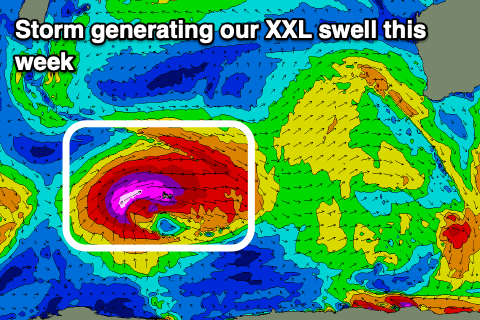 The storm has currently formed west of Heard Island and we're seeing a fetch of severe-gale to storm-force W/SW winds moving on top an active sea state, and projecting up towards us today before broadening and weakening tomorrow.
The swell is due to arrive really late Thursday and likely kick to 15ft+ across the South West by dark, with Friday morning easing from 18-20ft, 4-5ft across Mandurah and 3-4ft in Perth.
Winds will remain onshore Friday though, swinging from the W/SW to S/SW and then remaining onshore Saturday as the remnants of the storm linger in our swell window in form of a weaker cold front.
It won't be until Sunday that we'll see winds swing offshore, but this will be two whole days after the swell's peak though we should still see 6-8ft sets in the South West, 2-3ft Mandurah and 2ft Perth.
Following this we may see some good new W/SW groundswell for mid-next week, but more on this Wednesday.