Windy over the coming days with a new swell

Western Australia Surf Forecast by Craig Brokensha (issued Monday 6th April)
Best Days: Selected spots tomorrow afternoon, less so Wednesday morning, Thursday morning Perth and Mandurah, Friday morning
Recap
Tiny and clean conditions across Perth and Mandurah all weekend and today, with the South West offering the best waves, windy offshore and to 3-4ft Saturday, a touch smaller yesterday. Today conditions are clean again but the swell hanging in around a small but fun 3ft+ or so across the South West, tiny to the north.
This weekend and next week (Apr 7 - 12)
Moving into tomorrow and our inconsistent but good long-period W/SW groundswell is still on track, with it generated late last week and due to arrive this evening and fill in tomorrow, peaking through the afternoon.
The South West should build to 5-6ft on the sets across the swell magnets, 2ft in Mandurah and Perth along with a strong and unfavourable E/NE breeze early, swinging more N/NE with strength and then easing off later.
This isn't ideal at all so try those northerly friendly breaks into the afternoon for a wave.
Wednesday will see the swell easing under strong N/NE winds from dawn, shifting N/NW into the afternoon while easing a touch.
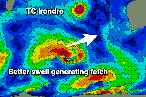 Looking further into the Indian Ocean and Tropical Cyclone Irondro is sitting some 2,500km+ west-northwest of us and currently weakening. The swell generating properties of this cyclone are poor with it breaking up over the coming 24 hours and tracking south-east with no decent swell generating fetch.
Of greater importance is a more noticeable W/SW-SW swell due to fill in Thursday, produced by a poorly structured low that formed in the middle of the Indian Ocean yesterday.
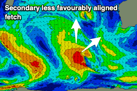
A good initial fetch of strong to near gale-force W/SW winds have been generated in our western swell window, followed by a less favourable fetch of stronger S/SW gales aimed more towards North Sumatra than us. This trough/storm will continue east while broadening and weakening tomorrow and then breaking down Wednesday.
 The swell from this system is due Thursday with Mandurah and Perth coming in at 2ft on the sets, with 4-6ft waves in the South West.
We'll see winds turn onshore in any case across the South West when this swell is due with a dawn N/NW tending S/SW breeze as the trough linked to ex-TC Irondro moves through, E tending S/SW further north. Therefore Perth and Mandurah will be the pick.
The swells should ease Friday from 1-2ft and 4-5ft respectively as winds shift gusty E/SE through the morning ahead of sea breezes.
Moving into the weekend we're looking at poor surf with a weak mid-latitude low forming west-southwest of us bringing onshore winds and a new swell for Sunday, while we may see a more favourably tracking polar frontal progression up and towards us early next week generating some better swell. More on this Wednesday though.
Comments
Double overhead sets (look closely) on the magnets with the new swell..