Improving surf late week, windy weekend

Western Australia Surf Forecast by Craig Brokensha (issued Monday 16th March)
Best Days: Thursday morning, Friday morning in the South West, protected spots in the South West Saturday morning, Sunday late morning onwards in the South West, similar Monday
Recap
Nice and clean with 3-4ft of leftover swell Saturday across the South West, 1-1.5ft in Mandurah and tiny in Perth. Come Sunday onshore winds kicked in with a further drop in swell.
Today the swell has come up a little but conditions are poor across all locations again.
This week and weekend (Mar 17 - 22)
The next couple of days looks poor for surf as a relatively weak mid-latitude front pushes up and into us bringing onshore W/NW winds tomorrow, strengthening through the day with a building windswell ahead of some better mid-period energy into Wednesday, easing Thursday.
We'll see the mid-period energy building to 6ft or so across the South West Wednesday afternoon, easing from the 5ft range Thursday morning. Perth and Mandurah should build to 2-3ft through Wednesday, easing back from 2ft Thursday morning.
Winds will remain onshore and out of the W/SW Wednesday, swinging SW through the day. Thursday looks cleaner with E/SE offshore winds developing across all locations through the day with the easing swell.
Fresh SE winds are due to kick back in on Friday along with a new mid-period SW swell.
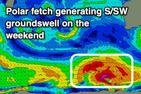 This and larger levels of S/SW groundswell expected into the weekend will be generated by polar fronts firing up within our south-western to southern swell windows over the coming week.
Friday's swell doesn't look too significant with building surf to 4ft or so in the South West, tiny to the north.
A series of stronger polar fronts moving through our swell window will produce some stronger S/SW groundswell on the weekend but only favouring the South West and not Perth and Mandurah.
Fetches of strong to gale-force W/SW winds forming through our southern swell window Wednesday evening through Saturday morning should produce moderate levels of swell, the first pulse due later Saturday and more so Sunday morning.
A good kick in size to 5-6ft on the sets is expected Sunday morning across the South West, 1-1.5ft in Mandurah and tiny in Perth, easing ahead of a secondary slightly smaller pulse Monday morning.
Winds on Saturday look hit and miss and strong from the SE, tending S/SE through the day with more favourable but tricky and strong E/SE breezes Sunday morning and then strong E Monday morning.
The pick of these days will be late morning-early afternoon as winds ease off ahead of sea breezes or go variable.
Longer term a new W/SW groundswell may be seen later week, but more on this Wednesday.