Average outlook ahead

Western Australia Surf Forecast by Craig Brokensha (issued Friday 13th March)
Best Days: Saturday across the swell magnets
Recap
Offshore winds and a mix of fun swell from Wednesday afternoon and building groundswell through the day, coming in at a bumpy 5-6ft in the South West, cleaner to the north but small. The swell became large into the afternoon across the South West but with average winds, similar to the north.
Today we've got cleaner conditions across all breaks with an easing S/SW groundswell from 6ft+ in the South West, 2ft+ in Mandurah and 1-2ft in Perth. Make the most of the swell as the outlook is looking much slower.
This weekend and next week (Mar 14 - 20)
Make the most of the current swell and conditions as the coming forecast isn't too flash at all.
We've got clean conditions due tomorrow across all regions with a fresh E/NE offshore tomorrow, tending variable into the afternoon in Perth and Mandurah, sea breezy across Margs along with an easing S/SW groundswell from today.
Perth looks tiny and to 1-1.5ft, 1ft to maybe 2ft in Mandurah and 4ft across the South West magnets, smaller through the day.
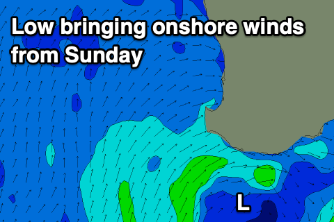 Come Sunday an unfavourable NW breeze is due to develop around dawn in the South West, W/NW into the afternoon as a small low forms off the coast, with a small and inconsistent background swell to 3ft to possibly 4ft.
Onshore winds will linger into Monday out of the W/SW-W, more W/NW-NW on Tuesday due to an approaching cold front.
The models diverge on how long the frontal progressions will continue to impact us through next week with EC seeing onshore winds right through until Thursday, while GFS has a high moving in quicker.
Either way there's no major swell on the cards with background mid-period energy keeping the South West around 4ft or so, with a bit more action on the cards for next weekend but out of the S/SW. We'll have a closer look at this on Monday though. Have a great weekend!