Larger surf on the way, worth making the most of

Western Australia Surf Forecast by Craig Brokensha (issued Wednesday 11th March)
Best Days: Tomorrow protected spots, Friday, Saturday in the South West and Mandurah, Sunday morning in the South West
Recap
Great conditions with a fun sized and easing swell from 4-5ft across the South West yesterday morning, 1-2ft in Perth and Mandurah.
This morning we've got clean conditions again and a building long-range W/SW groundswell that's already pushing to 5-6ft on the exposed reefs in the South West. Mandurah and Perth were tiny but should pulse in size during today, reaching 2ft this afternoon but with sea breezes.
The current groundswell has filled in a bit earlier than expected and we should see sets reaching 6ft+ across the South West this afternoon but with sea breezes.

This week and weekend (Mar 12 - 15)
While today's secondary pulse of W/SW groundswell has arrived a little earlier than expected, we're still expecting a similar drop in size tomorrow back to 5-6ft in the South West, 2ft in Perth and Mandurah.
Winds will be less favourable though and strong from the S/SE, favouring protected spots, while we'll see our large new S/SW groundswell arriving into the afternoon.
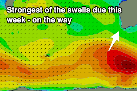 There's been no change to the expected size of this swell, with the polar frontal progression linked to it now gone, with surf expected to push to 8ft across the South West, 2-3ft in Mandurah and hold 2ft in Perth.
Winds will persist from the S/SE in the South West but be strong and sea breezey from the S/SW further north.
Friday is the pick as the swell eases from 6-8ft in the South West, 2-3ft in Mandurah and 2ft in Perth with gusty SE tending E/SE wind in the South West, easing mid-afternoon ahead of a possible late sea breeze, more variable to the north.
The swell will continue to ease into the weekend with fresh offshore E/NE winds on Saturday, lighter and E/NE again Sunday morning.
A small reinforcing SW groundswell should keep the South West magnets ticking at 3ft to possibly 4ft on Sunday, but with long waits between sets. Mandurah and Perth will become tiny.
A persistent progression of weak polar fronts will prevent the South West from going flat, but we'll only see background mid-period swells through early-mid next week and with what looks to be unfavourable winds.
Nothing really above 4ft is due across the South West and onshore S/SW tending W winds will create average conditions Monday, stronger Tuesday and Wednesday with a possible local increase in swell. More on this Friday though.
Comments
Looks like rain for the northwest cape.
A rarity.
.