Good run of swell and conditions next week

Western Australia Surf Forecast by Craig Brokensha (issued Friday 6th March)
Best Days: Every day next week in the South West, similar for Perth and Mandurah besides Tuesday and Wednesday mornings (too small)
Recap
A continuation of poor surf, tiny to the north and small and wind affected in the South West.
This weekend and next week (Mar 7 - 13)
Don't worry about surfing over the weekend. Conditions will remain poor with a drop in swell and onshore S/SW tending SW winds tomorrow, S-S/SE on Sunday morning but with a low point in swell.
We then move onto next week and the better conditions and good pulses of groundswell.
Our first pulse of long-period SW groundswell for Monday is being generated by a strong low that formed east of Heard Island, with a fetch of weakening severe-gale W'ly winds dipping south-east through our swell window.
Yesterday though we saw stronger, core, storm-force winds, producing a good long-period SW groundswell for Monday morning, kicking to 6ft on the sets across the South West, 2ft in Mandurah and 1-2ft across Perth along with moderate to fresh E/SE-E offshore winds, holding until early afternoon.
 Similar offshore and clean conditions are due on Tuesday as the swell eases in size, bottoming out Wednesday morning with clean conditions again.
We then look at the secondary pulse of long-period W/SW groundswell for later Wednesday and Thursday morning.
The source of this swell is more in our western swell window but more distant and further away, with a fetch of severe-gale to storm-force W/SW winds firing up south-east of South Africa today. The fetch will be short-lived though and we'll see a similar pulse of swell to Monday but with more west in the direction.
Inconsistent sets are due to reach 5-6ft by dark Wednesday, with a peak in size overnight, 2ft late in Mandurah and Perth. This will be with sea breezes, while Thursday morning should offer similar sized surf with morning offshore winds out of the E.
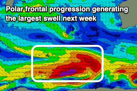
The third and reinforcing pulse of long-period SW groundswell due into later Thursday and Friday has now been upgraded, with the polar frontal progression generating it looking a bit better on paper.
A great fetch of pre-frontal W/NW gales will be closely followed by severe-gale W/SW winds through our south-western swell window, with a slight sting in the tail giving it that extra boost in size.
The swell should arrive later Thursday but peak Friday morning to 6-8ft+ across the South West swell magnets, 2-3ft in Mandurah and 2ft in Perth.
Local winds again look great and offshore out of the E/SE, before giving into sea breezes.
Moving into the weekend there'l be smaller surf and less favourable winds, continuing into early next week as weakening polar fronts push towards the South West corner of the state. More on this Monday though. Have a great weekend!
Comments
Looking alright for us above 26 parallel too light winds and a bit of swell
Yes!