Easing surf with cleaner conditions

Western Australia Surf Forecast by Craig Brokensha (issued Monday 30th December)
Best Days: Tomorrow morning, Wednesday morning, Thursday and Friday protected spots, the South West and Mandurah Saturday morning
Recap
A slight drop in size Saturday with Mandurah fairing the best with bumpy 1-2ft waves and cross-shore winds, tiny to the north and a bumpy 3-4ft in the South West.
A new W/SW swell filled in on Sunday with onshore winds, coming in at a bumpy 3ft around Mandurah, 2ft in Perth through the morning, but bigger through the day and building from 6ft+ across the South West.
The swell has eased back to 6-8ft across the South West this morning with a touch less onshore wind, great in Perth and Mandurah with cleaner conditions and great surf to 3ft on the later, 2-3ft in Perth.
This week and weekend (Dec 31 – Jan 4)
The surf is due to ease into tomorrow and conditions are looking cleaner across all locations with a light E/SE offshore in the South West, SE tending E/SE ahead of sea breezes to the north and easing sets from the 6ft range in the South West, 2ft to possibly 3ft in Mandurah and 2ft in Perth.
Wednesday will be clean again with morning offshores, but even less size.
As touched on last update, some mid-period W/SW swell is likely to build later Wednesday ahead of a larger but inconsistent W/SW groundswell on Thursday.
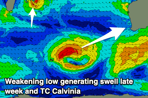 These swells have been generated by a strong low that formed south-east of Madagascar on the weekend and is now moving east towards us in a much weaker form.
Come Thursday as the inconsistent W/SW groundswell fills in we should see sets pushing to 8ft across the South West swell magnets, 2-3ft in Mandurah and Perth
Winds are still looking on track to be out of the S/SE, but not too strong so protected spots should have fun waves before sea breezes kick in.
Friday looks a little dicey with stronger S'ly winds across most locations as the swell eases from 5-6ft and 2ft respectively. Come the weekend offshore winds are expected each morning as the swell continues to ease so hit Margs for the size and best waves.
Longer term it looks like a tropical cyclone sitting east of Madagascar named Calvinia, weird name eh, will be absorbed into the westerly storm track and produce a tricky, moderate sized W'ly swell for us next week, but more on this Wednesday. Have a happy and safe New Year!