Fun tomorrow, good swell for next week

Western Australia Surf Forecast by Craig Brokensha (issued Friday 20th December)
Best Days: Margs and Mandurah tomorrow morning, Wednesday morning, Thursday morning
Recap
Poor conditions with a building swell across all regions yesterday, stormy into the afternoon and peaking in size this morning with the onshore wind persisting, but easing in strength. Margs is still a messy 6-8ft with cleaner 3ft waves in Mandurah, 2-3ft in Perth.
This weekend and next week (Dec 21 - 27)
Our current W/SW swell will ease through this afternoon and drop further tomorrow as winds swing offshore. There should be a reinforcing S/SW swell for the South West through the day, generated on the tail of a significant low forming just east of our swell window, but only impacting south swell magnets on the southern end of the cape.
Size wise, easing sets from 4-5ft are due across the Margs swell magnets, 1-2ft in Mandurah and 1-1.5ft in Perth.
Great E/SE tending E/NE winds are due across all locations ahead of sea breezes, and then less favourable S'ly winds on Sunday as the surf bottoms out.
Moving into Monday, an inconsistent SW swell is due to fill in, though only building back to 3-4ft+ across the South West, tiny to the north and with a morning SE wind ahead of S/SW sea breezes.
Tuesday isn't looking too flash as the swell eases with S/SE breezes.
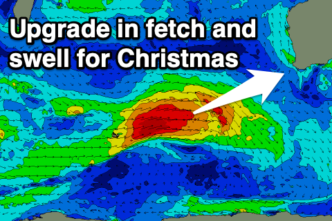 Of greater importance is the W/SW groundswell due into the middle of the week, and we've got an upgrade in the size from Wednesday with the bulk of the fetch in the progression linked to the swell now expected to be gale-force. The projection towards is is great as well, generating a large W/SW groundswell for Wednesday.
The swell should arrive early morning and build rapidly through the day, reaching 6-8ft+ through the afternoon, 2-3ft in Mandurah and 2ft to occasionally 3ft in Perth.
Winds on Wednesday as the swell builds look favourable and from the SE, giving into S/SW sea breezes as the swell peaks. Thursday looks a little suss now with S/SE winds in the South West as the swell eases from 6ft+, cleaner to the north and easing from 2ft to occasionally 3ft in Mandurah and 2ft in Perth.
The easing trend will be slowed into the end of the week owing to weaker back up fronts moving through our swell window. Winds will swing onshore though on Friday, possibly clean again Saturday but we'll have to review this on Monday.
Longer term a good new SW swell is on the cards for early next week, but check back Monday for more on this. Have a great weekend!
Comments
Decent swell being delivered for Xmas best present I'm going to get