Fun swells and generally favourable winds this period

Western Australia Surf Forecast by Craig Brokensha (issued Friday 13th December)
Best Days: Saturday morning, Sunday morning in the South West, Tuesday morning, Wednesday morning
Recap
A slow drop in size across Margs over the last two days, back from 4ft yesterday with strong offshore winds, 3ft today and a touch less wind. To the north conditions were mostly tiny yesterday, even smaller today.
This weekend and next week (Dec 14 - 20)
The weekend is looking fun with a new long-period pulse of W/SW groundswell due to arrive overnight and peak through tomorrow. This was generated by a short and intense low, producing a burst of severe-gale to storm-force W'ly winds before the storm weakened and dipped east-southeast and away from us.
Good 6ft to possibly 8ft sets are expected across the Margaret River swell magnets tomorrow, 2ft in Mandurah and 1-2ft in Perth. Winds are looking a little funky but likely light E'ly across most locations, shifting to the south ahead of sea breezes, with E/NE offshores Sunday morning as the swell eases from 4-5ft, tiny to the north.
Monday should be nice and clean early but the swell small and on the way out.
As touched on last update, a mid-latitude frontal progression is expected to develop west-southwest of us over the weekend.
An initial front will generate a not overly impressive fetch of strong to near gale-force W/SW winds. This front will dip east-southeast away from us on Sunday evening, with a secondary weaker front firing up right on its tail.
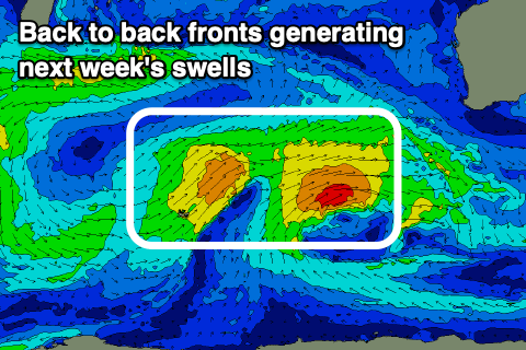 We'll see back to back pulses of mid-period W/SW swell, the first being a touch bigger than the second and arriving through Tuesday, building to 6ft+ across the South West into the afternoon, 2ft to possibly 3ft in Mandurah and 2ft in Perth.
The secondary pulse is due Wednesday, a bit better aligned for Perth and Mandurah, maintaining similar sized surf to Tuesday afternoon, with surf around 6ft in the South West.
Winds on Tuesday morning as the swell builds look OK though not great and S/SE-SE, with afternoon SW sea breezes, and great E/SE-E offshores on Wednesday morning with the secondary reinforcing W/SW swell.
We're now expected to see onshore winds move in with a deepening mid-latitude low forms off the South West late week, bringing a building close-range swell, small by the time it goes back offshore again. More on this Monday. Have a great weekend!