A few better surf days to choose from

Western Australia Surf Forecast by Craig Brokensha (issued Wednesday 20th November)
Best Days: Perth and Mandurah tomorrow morning, Friday morning in the South West, Saturday morning, Tuesday morning
Recap
A small lift in swell yesterday with early light winds before swinging fresh onshore as the swell kicked a bit more.
Today conditions are poor and building with strong onshore winds linked to a strong cold front pushing up and into us.
This week and weekend (Nov 21 - 24)
The front currently pushing up and into the state is generating a mix of windswell and mid-period energy, with a peak to 5-6ft expected in the South West, 2-3ft in Mandurah and 2ft+ in Perth.
The front will clear to the east this afternoon and evening resulting in a drop in size tomorrow from 4-5ft+ in the South West, 2ft+ in Mandurah and 2ft in Perth. Conditions will be average across all of the South West now with the next approaching front bringing SW tending W/SW winds, better to the north around Perth and Mandurah with a morning E/SE offshore.
 Friday will be cleaner in the South West with an early S/SE but low point in swell ahead of our new stronger SW groundswell into the afternoon.
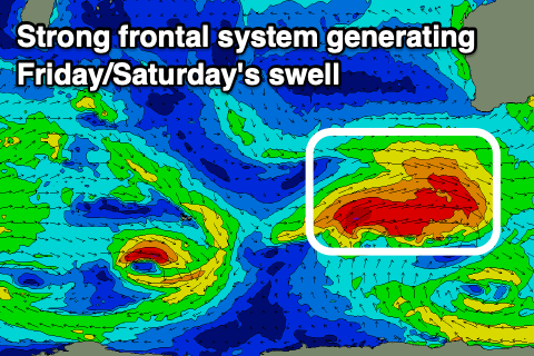
The front generating Friday/Saturday's swell is looking a little stronger, with a touch more size and power expected.
The swell is due to build through the morning, and peak into the afternoon to 6-8ft across the South West swell magnets, 2ft to occasionally 3ft in Mandurah and 2ft in Perth. This will be with sea breezes though. There should be a good window of decent conditions and building swell across the South West.
We'll see the surf ease into Saturday from 6ft on the sets in the South West, 2ft Mandurah and 1-2ft in Perth. Conditions are still looking good though with a E/SE-SE offshore wind across most locations ahead of sea breezes.
Winds on Sunday as the swell continues to ease look dicey and out of the S/SE, limiting surfing options, especially with the small swell.
Into next week there's nothing too significant on the cards, with the best swell due to fill in Monday.
This will be a small to moderate sized SW groundswell, produced by a tight low generating a fetch of W/SW gales Friday and Saturday.
No major size is expected from this low, with Margs due to build to 4-5ft+ Monday afternoon, 1-2ft in Mandurah and 1-1.5ft across Perth. A morning SE breeze will give into afternoon sea breezes, best Tuesday as the swell eases with a light morning E/SE offshore.
Beyond this some weak, windy S/SW swell is on the cards late week, but more on this Friday.