Tons of swell and tons of wind

Western Australia Surf Forecast by Craig Brokensha (issued Wednesday 19th June)
Best Days: Perth and Mandurah tomorrow morning, possibly Margs through the day, Perth and Mandurah Monday and Tuesday mornings
Recap
Smaller surf yesterday but great conditions with 4-5ft waves in the South West, 2-3ft sets around Mandurah and 1-2ft waves in Perth.
Today our large new long-period W/SW groundswell has filled in and with pumping conditions across the South West. Clean, groomed and super lined up 10ft+ waves on the magnets with 3ft sets in Mandurah and building 2-3ft surf in Perth.

Today’s Forecaster Notes are brought to you by Rip Curl
This week and weekend (Jun 22 - 28)
Make the most of today, as from tomorrow we'll see conditions deteriorate across the state.
Today's large and inconsistent W/SW groundswell will ease off in size and Perth and Mandurah should see an early and fresh NE breeze, tending N/NE and strengthening through the day. Margs is tricky.
 The hi-res wind modelling has a dawn onshore wind from the W/NW-N/NW possibly tending E/NE through the early afternoon ahead of a strong SW change. Either way it'll be dicey and not worth chasing.
Size wise we should see today's swell easing from 6-8ft on the sets across the South West, 2-3ft in Mandurah and Perth.
From Sunday all locations will be onshore with a strengthening W/NW breeze as a mid-latitude front races in from the west.
This will be the first of a series of strong and significant storms projecting up and into us over the coming period as a strong node of the Long Wave Trough stalls to our west.
A lift in new W/SW groundswell and late increase in windswell are due on Sunday, with Monday revealing the most size but it's all academic with the wind persisting from the W/NW tending NW.
Perth and Mandurah may actually see early light NE winds on Monday morning with the new mid-period W/SW swell coming in at 2-3ft and 3ft respectively.
Tuesday will definitely see winds out of the NE through the morning as the swell from Monday eases back to 2ft or so around Perth and Mandurah. Margs will see poor and strengthening N/NW winds.
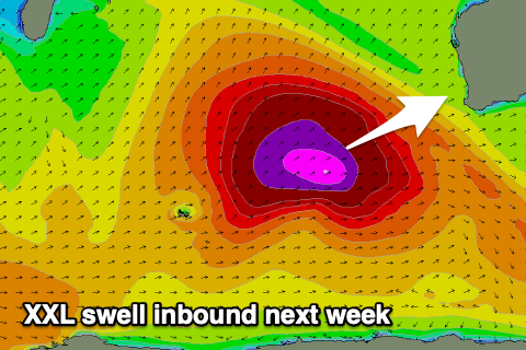
Moving into the middle of the week and we're set to see one of the largest if, not the largest groundswell event of the year.
The Long Wave Trough will super-charge a significant polar frontal system over the weekend, with an expansive fetch of severe-gale W/SW winds due to project up and towards us. A large open ocean active sea state and groundswell in its own right will be generated, but a secondary burst of storm-force W/SW winds acting on top this and projecting towards us will generate an XXL long-period W/SW groundswell for us.
An oversized W/SW groundswell will build Wednesday but the XXL swell proper is due on Thursday with Margs expected to come in around 15-20ft across the outer reefs, 4-6ft in Mandurah and 3-5ft in Perth.
Winds will be the issue though with a strong NW wind most of Wednesday as the swell builds, and W/NW winds as it peaks Thursday.
A ridge of high pressure looks to move in on Friday and with this we'll hopefully see winds swing S/SE as the swell still has size and eases.
Longer term there's plenty more swell activity on the cards, but more on this Monday. Have a great weekend!